Gönen geodata
Gönen (Balıkesir) is a seat of a second-order administrative division; located in Turkey in Europe/Istanbul (GMT+3) time zone. With population of 40,763 people, there are 202 cities with bigger population in this country. Compared to other cities in Turkey, 71% of cities are located further ↓South; 92.6% of cities are located further →East and 89.9% of cities have higher elevation than Gönen. Note1


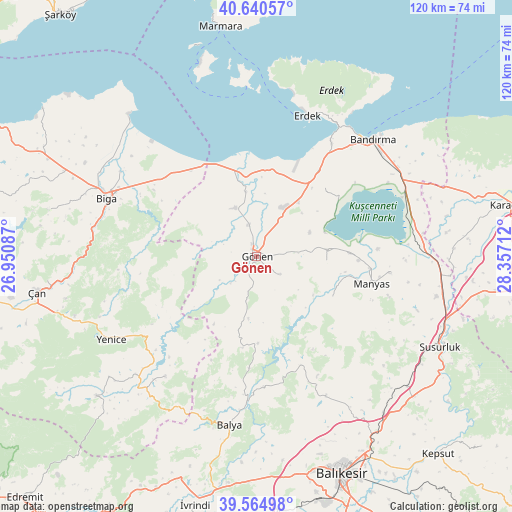
Gönen GPS coordinates[2]
40° 6' 17.64" North, 27° 39' 14.364" East
| Map corner | latitude | longitude |
|---|---|---|
| Upper-left | 40.64057°, | 26.95087° |
| Center: | 40.1049°, | 27.65399° |
| Lower-right: | 39.56498°, | 28.35712° |
| Map W x H: | 119.6×119.6 km | = 74.3×74.3mi |
| max Lat: | 42.02683° ⇑29% North |
| Gönen: | 40.1049° |
| min Lat: | ⇓71% South 35.9025° |
| min Long | Gönen | max Long |
| 25.90902° | 27.65399° | 44.60099° |
| W 7.4%⇐ | ⇒92.6% E |
Elevation
Elevation of Gönen is 40 m = 131 ft, and this is 677.4 m = 2222 ft below average elevation for this country.
| Max E: |
2682 m = 8799 ft | 89.9% |
| Avg. | 717.4 m = 2354 ft | |
| Gönen | 40 m = 131 ft | |
Min E: |
0 m = 0 ft | 10.1% |
See also: Gönen elevation on elevation.city.
Geographical zone
Gönen is located in North temperate zone (between Tropic of Cancer and the Arctic Circle). Distance of this Northern Tropic circle is 1853.3 km =1151.6 mi to South.| Distance of | km | miles | from Gönen |
|---|---|---|---|
| North Pole | 5547.8 | 3447.2 | to North |
| Arctic Circle | 2941.9 | 1828 | to North |
| Tropic Cancer | 1853.3 | 1151.6 | to South |
| Equator | 4459.2 | 2770.8 | to South |


Nearby cities:
15 places around Gönen: (largest is in red/bold)
• Biga
37.6 km =23.4 mi,  291°
291°
• Buğdaylı
16.1 km =10 mi,  38°
38°
• Danişment
26.3 km =16.3 mi,  183°
183°
• Darıca
20.2 km =12.6 mi,  117°
117°
• Dimetoka
37.2 km =23.1 mi,  301°
301°
• Edincik
31.7 km =19.7 mi,  33°
33°
• Erdek
34.8 km =21.6 mi,  19°
19°
• Ilıca
27.5 km =17.1 mi,  157°
157°
• Manyas
27.7 km =17.2 mi,  103°
103°
• Pazarköy
35.2 km =21.9 mi,  217°
217°
• Sarıköy
12.4 km =7.7 mi,  336°
336°
• Sinekçi
28 km =17.4 mi,  311°
311°
• Tütüncü
7 km =4.3 mi,  127°
127°
• Şamlı
36.4 km =22.6 mi,  153°
153°
• Şevketiye
16.4 km =10.2 mi,  94°
94°
Sources, notices
• [Note1] Compared only with cities in Turkey existing in our database
• [Src1] Map data: © OpenStreetMap contributors (CC-BY-SA)
• [Src2] Other city data from geonames.org with taken over terms of usage.
• [Src3] Geographical zone / Annual Mean Temperature by Robert A. Rohde @ Wikipedia
