Manyas geodata
Manyas (Balıkesir) is a seat of a second-order administrative division; located in Turkey in Europe/Istanbul (GMT+3) time zone. With population of 5,327 people, there are 696 cities with bigger population in this country. Compared to other cities in Turkey, 70% of cities are located further ↓South; 90.5% of cities are located further →East and 87.4% of cities have higher elevation than Manyas. Note1


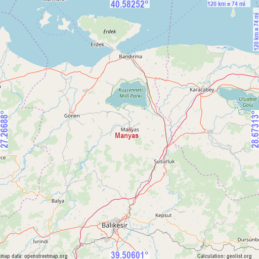
Manyas GPS coordinates[2]
40° 2' 47.004" North, 27° 58' 12" East
| Map corner | latitude | longitude |
|---|---|---|
| Upper-left | 40.58252°, | 27.26688° |
| Center: | 40.04639°, | 27.97° |
| Lower-right: | 39.50601°, | 28.67313° |
| Map W x H: | 119.7×119.7 km | = 74.4×74.4mi |
| max Lat: | 42.02683° ⇑30% North |
| Manyas: | 40.04639° |
| min Lat: | ⇓70% South 35.9025° |
| min Long | Manyas | max Long |
| 25.90902° | 27.97° | 44.60099° |
| W 9.5%⇐ | ⇒90.5% E |
Elevation
Elevation of Manyas is 55 m = 180 ft, and this is 662.4 m = 2173 ft below average elevation for this country.
| Max E: |
2682 m = 8799 ft | 87.4% |
| Avg. | 717.4 m = 2354 ft | |
| Manyas | 55 m = 180 ft | |
Min E: |
0 m = 0 ft | 12.6% |
See also: Turkey elevation on elevation.city.
Geographical zone
Manyas is located in North temperate zone (between Tropic of Cancer and the Arctic Circle). Distance of this Northern Tropic circle is 1846.8 km =1147.5 mi to South.| Distance of | km | miles | from Manyas |
|---|---|---|---|
| North Pole | 5554.3 | 3451.3 | to North |
| Arctic Circle | 2948.4 | 1832.1 | to North |
| Tropic Cancer | 1846.8 | 1147.5 | to South |
| Equator | 4452.7 | 2766.8 | to South |


Nearby cities:
15 places around Manyas: (largest is in red/bold)
• Aksakal
16.2 km =10.1 mi,  46°
46°
• Bandırma
34 km =21.1 mi,  0°
0°
• Buğdaylı
25.6 km =15.9 mi,  318°
318°
• Darıca
9.5 km =5.9 mi,  252°
252°
• Edincik
34.2 km =21.3 mi,  344°
344°
• Göbel
15.2 km =9.4 mi,  101°
101°
• Gönen
27.7 km =17.2 mi,  283°
283°
• Ilıca
25.1 km =15.6 mi,  221°
221°
• Susurluk
21.8 km =13.5 mi,  132°
132°
• Tatkavaklı
33.8 km =21 mi,  92°
92°
• Tütüncü
21.4 km =13.3 mi, 276°
• Yeniköy
29.9 km =18.6 mi,  174°
174°
• Ömerköy
25.4 km =15.8 mi,  161°
161°
• Şamlı
28.2 km =17.5 mi,  202°
202°
• Şevketiye
11.7 km =7.3 mi,  296°
296°
Sources, notices
• [Note1] Compared only with cities in Turkey existing in our database
• [Src1] Map data: © OpenStreetMap contributors (CC-BY-SA)
• [Src2] Other city data from geonames.org with taken over terms of usage.
• [Src3] Geographical zone / Annual Mean Temperature by Robert A. Rohde @ Wikipedia
