Yuvacık geodata
Yuvacık (Kocaeli) is a populated place; located in Turkey in Europe/Istanbul (GMT+3) time zone. With population of 7,338 people, there are 603 cities with bigger population in this country. Compared to other cities in Turkey, 80.8% of cities are located further ↓South; 76.1% of cities are located further →East and 75.7% of cities have higher elevation than Yuvacık. Note1


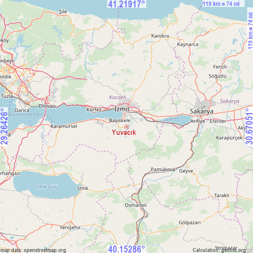
Yuvacık GPS coordinates[2]
40° 41' 17.34" North, 29° 58' 2.568" East
| Map corner | latitude | longitude |
|---|---|---|
| Upper-left | 41.21917°, | 29.26426° |
| Center: | 40.68815°, | 29.96738° |
| Lower-right: | 40.15286°, | 30.67051° |
| Map W x H: | 118.6×118.6 km | = 73.7×73.7mi |
| max Lat: | 42.02683° ⇑19.2% North |
| Yuvacık: | 40.68815° |
| min Lat: | ⇓80.8% South 35.9025° |
| min Long | Yuvacık | max Long |
| 25.90902° | 29.96738° | 44.60099° |
| W 23.9%⇐ | ⇒76.1% E |
Elevation
Elevation of Yuvacık is 166 m = 545 ft, and this is 551.4 m = 1809 ft below average elevation for this country.
| Max E: |
2682 m = 8799 ft | 75.7% |
| Avg. | 717.4 m = 2354 ft | |
| Yuvacık | 166 m = 545 ft | |
Min E: |
0 m = 0 ft | 24.3% |
See also: Turkey elevation on elevation.city.
Geographical zone
Yuvacık is located in North temperate zone (between Tropic of Cancer and the Arctic Circle). Distance of this Northern Tropic circle is 1918.2 km =1191.9 mi to South.| Distance of | km | miles | from Yuvacık |
|---|---|---|---|
| North Pole | 5483 | 3407 | to North |
| Arctic Circle | 2877.1 | 1787.7 | to North |
| Tropic Cancer | 1918.2 | 1191.9 | to South |
| Equator | 4524.1 | 2811.1 | to South |


Nearby cities:
15 places around Yuvacık: (largest is in red/bold)
• Bahçecik
5 km =3.1 mi,  243°
243°
• Büyükderbent
12.6 km =7.8 mi,  80°
80°
• Derince
15 km =9.3 mi,  300°
300°
• Değirmendere
16.1 km =10 mi,  282°
282°
• Elmalı
20.5 km =12.7 mi,  200°
200°
• Gölcük
8.2 km =5.1 mi, 281°
• Halıdere
18.4 km =11.4 mi, 279°
• Karşıyaka
2.3 km =1.4 mi,  285°
285°
• Kullar
4.4 km =2.7 mi,  24°
24°
• Körfez
17.9 km =11.1 mi, 299°
• Köseköy
6.6 km =4.1 mi,  29°
29°
• Nüzhetiye
10.3 km =6.4 mi, 238°
• Ulaşlı
23 km =14.3 mi,  274°
274°
• İhsaniye
11.2 km =7 mi, 271°
• İzmit
9.1 km =5.7 mi,  339°
339°
Sources, notices
• [Note1] Compared only with cities in Turkey existing in our database
• [Src1] Map data: © OpenStreetMap contributors (CC-BY-SA)
• [Src2] Other city data from geonames.org with taken over terms of usage.
• [Src3] Geographical zone / Annual Mean Temperature by Robert A. Rohde @ Wikipedia
