Gebze geodata
Gebze (Kocaeli) is a seat of a second-order administrative division; located in Turkey in Europe/Istanbul (GMT+3) time zone. With population of 281,436 people, there are 37 cities with bigger population in this country. Compared to other cities in Turkey, 83.7% of cities are located further ↓South; 79.9% of cities are located further →East and 74.6% of cities have higher elevation than Gebze. Note1


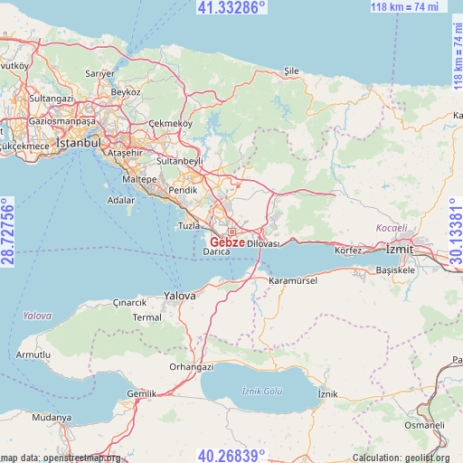
Gebze GPS coordinates[2]
40° 48' 9.936" North, 29° 25' 50.448" East
| Map corner | latitude | longitude |
|---|---|---|
| Upper-left | 41.33286°, | 28.72756° |
| Center: | 40.80276°, | 29.43068° |
| Lower-right: | 40.26839°, | 30.13381° |
| Map W x H: | 118.4×118.4 km | = 73.6×73.6mi |
| max Lat: | 42.02683° ⇑16.3% North |
| Gebze: | 40.80276° |
| min Lat: | ⇓83.7% South 35.9025° |
| min Long | Gebze | max Long |
| 25.90902° | 29.43068° | 44.60099° |
| W 20.1%⇐ | ⇒79.9% E |
Elevation
Elevation of Gebze is 182 m = 597 ft, and this is 535.4 m = 1757 ft below average elevation for this country.
| Max E: |
2682 m = 8799 ft | 74.6% |
| Avg. | 717.4 m = 2354 ft | |
| Gebze | 182 m = 597 ft | |
Min E: |
0 m = 0 ft | 25.4% |
See also: Gebze elevation on elevation.city.
Geographical zone
Gebze is located in North temperate zone (between Tropic of Cancer and the Arctic Circle). Distance of this Northern Tropic circle is 1930.9 km =1199.8 mi to South.| Distance of | km | miles | from Gebze |
|---|---|---|---|
| North Pole | 5470.2 | 3399 | to North |
| Arctic Circle | 2864.3 | 1779.8 | to North |
| Tropic Cancer | 1930.9 | 1199.8 | to South |
| Equator | 4536.8 | 2819 | to South |


Nearby cities:
15 places around Gebze: (largest is in red/bold)
• Altınova
13.7 km =8.5 mi,  150°
150°
• Balçık
7.8 km =4.8 mi,  358°
358°
• Darıca
4 km =2.5 mi,  229°
229°
• Dereköy
19 km =11.8 mi,  143°
143°
• Hereke
15.6 km =9.7 mi,  96°
96°
• Kaytazdere
15.9 km =9.9 mi, 147°
• Mollafeneri
10.7 km =6.6 mi,  30°
30°
• Pendik
15.7 km =9.8 mi,  301°
301°
• Soğuksu
16.1 km =10 mi,  156°
156°
• Tavşancıl
12.4 km =7.7 mi,  106°
106°
• Tavşanlı
7 km =4.3 mi,  75°
75°
• Taşköprü
14.7 km =9.1 mi,  193°
193°
• Çayırova
4.4 km =2.7 mi,  323°
323°
• Çiftlikköy
18.2 km =11.3 mi,  209°
209°
• İçmeler
11.3 km =7 mi, 295°
Sources, notices
• [Note1] Compared only with cities in Turkey existing in our database
• [Src1] Map data: © OpenStreetMap contributors (CC-BY-SA)
• [Src2] Other city data from geonames.org with taken over terms of usage.
• [Src3] Geographical zone / Annual Mean Temperature by Robert A. Rohde @ Wikipedia
