Balçık geodata
Balçık (Kocaeli) is a populated place; located in Turkey in Europe/Istanbul (GMT+3) time zone. With population of 1,102 people, there are 1066 cities with bigger population in this country. Compared to other cities in Turkey, 85.2% of cities are located further ↓South; 79.9% of cities are located further →East and 73.2% of cities have higher elevation than Balçık. Note1


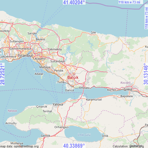
Balçık GPS coordinates[2]
40° 52' 21" North, 29° 25' 41.988" East
| Map corner | latitude | longitude |
|---|---|---|
| Upper-left | 41.40204°, | 28.72521° |
| Center: | 40.8725°, | 29.42833° |
| Lower-right: | 40.33869°, | 30.13146° |
| Map W x H: | 118.2×118.2 km | = 73.4×73.4mi |
| max Lat: | 42.02683° ⇑14.8% North |
| Balçık: | 40.8725° |
| min Lat: | ⇓85.2% South 35.9025° |
| min Long | Balçık | max Long |
| 25.90902° | 29.42833° | 44.60099° |
| W 20.1%⇐ | ⇒79.9% E |
Elevation
Elevation of Balçık is 209 m = 686 ft, and this is 508.4 m = 1668 ft below average elevation for this country.
| Max E: |
2682 m = 8799 ft | 73.2% |
| Avg. | 717.4 m = 2354 ft | |
| Balçık | 209 m = 686 ft | |
Min E: |
0 m = 0 ft | 26.8% |
See also: Turkey elevation on elevation.city.
Geographical zone
Balçık is located in North temperate zone (between Tropic of Cancer and the Arctic Circle). Distance of this Northern Tropic circle is 1938.7 km =1204.7 mi to South.| Distance of | km | miles | from Balçık |
|---|---|---|---|
| North Pole | 5462.5 | 3394.2 | to North |
| Arctic Circle | 2856.6 | 1775 | to North |
| Tropic Cancer | 1938.7 | 1204.7 | to South |
| Equator | 4544.6 | 2823.9 | to South |


Nearby cities:
15 places around Balçık: (largest is in red/bold)
• Altınova
20.9 km =13 mi,  160°
160°
• Darıca
10.7 km =6.6 mi,  195°
195°
• Gebze
7.8 km =4.8 mi,  178°
178°
• Hereke
18.4 km =11.4 mi,  121°
121°
• Kaytazdere
22.9 km =14.2 mi, 157°
• Mollafeneri
5.8 km =3.6 mi,  74°
74°
• Pendik
13.1 km =8.1 mi,  272°
272°
• Samandıra
22.1 km =13.7 mi,  309°
309°
• Sancaktepe
21.9 km =13.6 mi, 311°
• Sultanbeyli
16.5 km =10.3 mi, 306°
• Tavşancıl
16.5 km =10.3 mi,  133°
133°
• Tavşanlı
9.2 km =5.7 mi, 130°
• Taşköprü
22.3 km =13.9 mi,  188°
188°
• Çayırova
4.9 km =3 mi,  209°
209°
• İçmeler
10.5 km =6.5 mi,  253°
253°
Sources, notices
• [Note1] Compared only with cities in Turkey existing in our database
• [Src1] Map data: © OpenStreetMap contributors (CC-BY-SA)
• [Src2] Other city data from geonames.org with taken over terms of usage.
• [Src3] Geographical zone / Annual Mean Temperature by Robert A. Rohde @ Wikipedia
