Dereköy geodata
Dereköy (Kocaeli) is a populated place; located in Turkey in Europe/Istanbul (GMT+3) time zone. With population of 945 people, there are 1102 cities with bigger population in this country. Compared to other cities in Turkey, 80.2% of cities are located further ↓South; 78.9% of cities are located further →East and 69.5% of cities have higher elevation than Dereköy. Note1


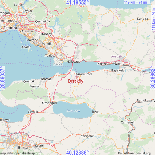
Dereköy GPS coordinates[2]
40° 39' 51.624" North, 29° 33' 48.564" East
| Map corner | latitude | longitude |
|---|---|---|
| Upper-left | 41.19555°, | 28.86037° |
| Center: | 40.66434°, | 29.56349° |
| Lower-right: | 40.12886°, | 30.26662° |
| Map W x H: | 118.6×118.6 km | = 73.7×73.7mi |
| max Lat: | 42.02683° ⇑19.8% North |
| Dereköy: | 40.66434° |
| min Lat: | ⇓80.2% South 35.9025° |
| min Long | Dereköy | max Long |
| 25.90902° | 29.56349° | 44.60099° |
| W 21.1%⇐ | ⇒78.9% E |
Elevation
Elevation of Dereköy is 318 m = 1043 ft, and this is 399.4 m = 1310 ft below average elevation for this country.
| Max E: |
2682 m = 8799 ft | 69.5% |
| Avg. | 717.4 m = 2354 ft | |
| Dereköy | 318 m = 1043 ft | |
Min E: |
0 m = 0 ft | 30.5% |
See also: Turkey elevation on elevation.city.
Geographical zone
Dereköy is located in North temperate zone (between Tropic of Cancer and the Arctic Circle). Distance of this Northern Tropic circle is 1915.5 km =1190.2 mi to South.| Distance of | km | miles | from Dereköy |
|---|---|---|---|
| North Pole | 5485.6 | 3408.6 | to North |
| Arctic Circle | 2879.7 | 1789.4 | to North |
| Tropic Cancer | 1915.5 | 1190.2 | to South |
| Equator | 4521.5 | 2809.5 | to South |


Nearby cities:
15 places around Dereköy: (largest is in red/bold)
• Altınova
5.7 km =3.5 mi,  306°
306°
• Gebze
19 km =11.8 mi,  323°
323°
• Halıdere
16.9 km =10.5 mi,  70°
70°
• Hereke
14.2 km =8.8 mi,  17°
17°
• Karamürsel
5.4 km =3.4 mi,  56°
56°
• Kaytazdere
3.3 km =2.1 mi, 307°
• Kılıç
14.7 km =9.1 mi,  256°
256°
• Soğuksu
4.7 km =2.9 mi,  278°
278°
• Tavşancıl
11.9 km =7.4 mi,  3°
3°
• Tavşanlı
17.7 km =11 mi,  345°
345°
• Taşköprü
14.6 km =9.1 mi,  274°
274°
• Ulaşlı
12.1 km =7.5 mi, 67°
• Yalakdere
6.4 km =4 mi,  180°
180°
• Çakırlı
18.8 km =11.7 mi,  210°
210°
• Çukurköy
14.6 km =9.1 mi,  242°
242°
Sources, notices
• [Note1] Compared only with cities in Turkey existing in our database
• [Src1] Map data: © OpenStreetMap contributors (CC-BY-SA)
• [Src2] Other city data from geonames.org with taken over terms of usage.
• [Src3] Geographical zone / Annual Mean Temperature by Robert A. Rohde @ Wikipedia
