Scarborough geodata
Scarborough (Tobago) is a seat of a first-order administrative division; located in Trinidad and Tobago in America/Port_of_Spain (GMT-4) time zone. With population of 17,000 people, there are 10 cities with bigger population in this country. Compared to other cities in Trinidad and Tobago, 100% of cities are located further ↓South; 100% of cities are located further ←West and 86.4% of cities have higher elevation than Scarborough. Note1


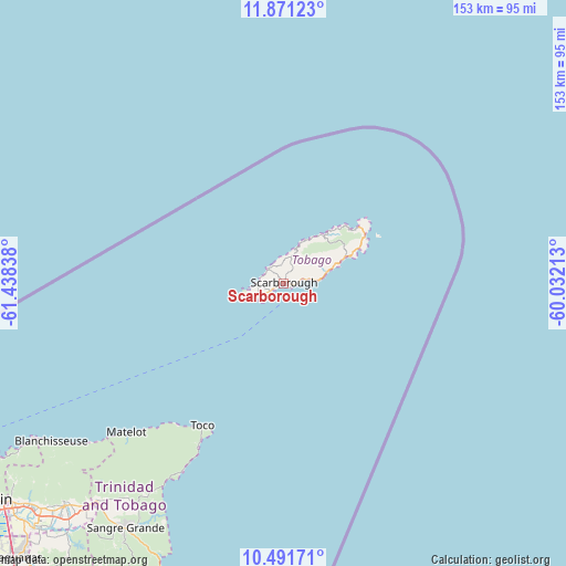
Scarborough GPS coordinates[2]
11° 10' 56.244" North, 60° 44' 6.9" West
| Map corner | latitude | longitude |
|---|---|---|
| Upper-left | 11.87123°, | -61.43838° |
| Center: | 11.18229°, | -60.73525° |
| Lower-right: | 10.49171°, | -60.03213° |
| Map W x H: | 153.4×153.4 km | = 95.3×95.3mi |
| max Lat: | 11.18229° ⇑0% North |
| Scarborough: | 11.18229° |
| min Lat: | ⇓100% South 10.14525° |
| min Long | Scarborough | max Long |
| -61.68407° | -60.73525° | -60.73525° |
| W 100%⇐ | ⇒0% E |
Elevation
Elevation of Scarborough is 9 m = 30 ft, and this is 27.9 m = 92 ft below average elevation for this country.
| Max E: |
100 m = 328 ft | 86.4% |
| Avg. | 36.9 m = 121 ft | |
| Scarborough | 9 m = 30 ft | |
Min E: |
3 m = 10 ft | 13.6% |
See also: Trinidad and Tobago elevation on elevation.city.
Geographical zone
Scarborough is located in North Torrid zone (between Equator and Tropic of Cancer). Distance of Equator is 1243.4 km =772.6 mi to South.| Distance of | km | miles | from Scarborough |
|---|---|---|---|
| North Pole | 8763.7 | 5445.5 | to North |
| Arctic Circle | 6157.8 | 3826.3 | to North |
| Tropic Cancer | 1362.6 | 846.7 | to North |
| Equator | 1243.4 | 772.6 | to South |


Nearby cities:
15 places around Scarborough: (largest is in red/bold)
• Arima
85.1 km =52.9 mi,  224°
224°
• Arouca
89.9 km =55.9 mi,  226°
226°
• Chaguanas
105 km =65.2 mi, 225°
• Couva
116.3 km =72.3 mi, 223°
• Diego Martin
104.2 km =64.7 mi,  240°
240°
• Laventille
102.3 km =63.6 mi, 234°
• Mucurapo
104.9 km =65.2 mi, 236°
• Paradise
90.3 km =56.1 mi, 229°
• Petit Valley
103.6 km =64.4 mi, 238°
• Port of Spain
103 km =64 mi, 236°
• Princes Town
122.8 km =76.3 mi,  214°
214°
• Rio Claro
108.7 km =67.5 mi, 206°
• Sangre Grande
79 km =49.1 mi, 213°
• Tabaquite
107.5 km =66.8 mi, 214°
• Tunapuna
92.5 km =57.5 mi, 230°
Sources, notices
• [Note1] Compared only with cities in Trinidad and Tobago existing in our database
• [Src1] Map data: © OpenStreetMap contributors (CC-BY-SA)
• [Src2] Other city data from geonames.org with taken over terms of usage.
• [Src3] Geographical zone / Annual Mean Temperature by Robert A. Rohde @ Wikipedia
