Nangan geodata
Nangan (Fukien) is a seat of a second-order administrative division; located in Taiwan in Asia/Taipei (GMT+8) time zone. In our database, there are 25 cities with bigger population. Compared to other cities in Taiwan, 100% of cities are located further ↓South; 94.6% of cities are located further →East and 73% of cities have lower elevation than Nangan. Note1
Administrative division(s):
- Level 1: Fukien
- Level 2: Lienchiang
- Level 3: Nangan Township
- Level 4: Qingshui Village


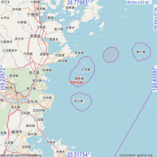
Nangan GPS coordinates[2]
26° 9' 1.404" North, 119° 55' 58.224" East
| Map corner | latitude | longitude |
|---|---|---|
| Upper-left | 26.77983°, | 119.22972° |
| Center: | 26.15039°, | 119.93284° |
| Lower-right: | 25.51754°, | 120.63597° |
| Map W x H: | 140.4×140.4 km | = 87.2×87.2mi |
| max Lat: | 26.15039° ⇑0% North |
| Nangan: | 26.15039° |
| min Lat: | ⇓100% South 22.00417° |
| min Long | Nangan | max Long |
| 118.31712° | 119.93284° | 121.84424° |
| W 5.4%⇐ | ⇒94.6% E |
Elevation
Elevation of Nangan is 74 m = 243 ft, and this is 4.5 m = 15 ft below average elevation for this country.
| Max E: |
505 m = 1657 ft | 27% |
| Avg. | 78.5 m = 258 ft | |
| Nangan | 74 m = 243 ft | |
Min E: |
8 m = 26 ft | 73% |
See also: Taiwan elevation on elevation.city.
Geographical zone
Nangan is located in North temperate zone (between Tropic of Cancer and the Arctic Circle). Distance of this Northern Tropic circle is 301.7 km =187.5 mi to South.| Distance of | km | miles | from Nangan |
|---|---|---|---|
| North Pole | 7099.4 | 4411.4 | to North |
| Arctic Circle | 4493.5 | 2792.1 | to North |
| Tropic Cancer | 301.7 | 187.5 | to South |
| Equator | 2907.7 | 1806.8 | to South |


Nearby cities:
15 places around Nangan: (largest is in red/bold)
• Banqiao
199.1 km =123.7 mi,  129°
129°
• Chang-hua
239.5 km =148.8 mi,  164°
164°
• Daxi
195.9 km =121.7 mi,  135°
135°
• Fengyuan
225.5 km =140.1 mi, 159°
• Hsinchu
182.3 km =113.3 mi,  145°
145°
• Jiufen
223.8 km =139.1 mi,  121°
121°
• Keelung
214 km =133 mi, 122°
• Miaoli
197.8 km =122.9 mi, 153°
• Taichung
235.2 km =146.1 mi, 161°
• Taipei
201.8 km =125.4 mi, 127°
• Taoyuan
189.7 km =117.9 mi, 132°
• Taoyuan City
187.8 km =116.7 mi, 133°
• Xindian
208.5 km =129.6 mi, 129°
• Yilan
239.6 km =148.9 mi, 130°
• Zhubei
181.4 km =112.7 mi, 143°
Sources, notices
• [Note1] Compared only with cities in Taiwan existing in our database
• [Src1] Map data: © OpenStreetMap contributors (CC-BY-SA)
• [Src2] Other city data from geonames.org with taken over terms of usage.
• [Src3] Geographical zone / Annual Mean Temperature by Robert A. Rohde @ Wikipedia
