Makuyuni geodata
Makuyuni (Tanga) is a populated place; located in Tanzania in Africa/Dar_es_Salaam (GMT+3) time zone. With population of 15,516 people, there are 180 cities with bigger population in this country. Compared to other cities in Tanzania, 60.5% of cities are located further ↓South; 74.1% of cities are located further ←West and 71.7% of cities have higher elevation than Makuyuni. Note1


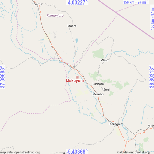
Makuyuni GPS coordinates[2]
4° 43' 59.988" South, 38° 6' 0" East
| Map corner | latitude | longitude |
|---|---|---|
| Upper-left | -4.03227°, | 37.39688° |
| Center: | -4.73333°, | 38.1° |
| Lower-right: | -5.43368°, | 38.80313° |
| Map W x H: | 155.8×155.8 km | = 96.8×96.8mi |
| max Lat: | -1.14389° ⇑39.5% North |
| Makuyuni: | -4.73333° |
| min Lat: | ⇓60.5% South -11.36667° |
| min Long | Makuyuni | max Long |
| 29.62667° | 38.1° | 40.33333° |
| W 74.1%⇐ | ⇒25.9% E |
Elevation
Elevation of Makuyuni is 479 m = 1572 ft, and this is 463.8 m = 1522 ft below average elevation for this country.
| Max E: |
2377 m = 7799 ft | 71.7% |
| Avg. | 942.8 m = 3093 ft | |
| Makuyuni | 479 m = 1572 ft | |
Min E: |
0 m = 0 ft | 28.3% |
See also: Tanzania elevation on elevation.city.
Geographical zone
Makuyuni is located in South Torrid zone (between Equator and Tropic of Capricorn). Distance of Equator is 526.3 km =327 mi to North.| Distance of | km | miles | from Makuyuni |
|---|---|---|---|
| Equator | 526.3 | 327 | to North |
| Tropic Capricorn | 2079.6 | 1292.2 | to South |
| Antarctic Circle | 6874.9 | 4271.9 | to South |
| South Pole | 9480.8 | 5891.1 | to South |


Nearby cities:
15 places around Makuyuni: (largest is in red/bold)
• Chanika
76.5 km =47.5 mi,  186°
186°
• Hedaru
34.1 km =21.2 mi,  319°
319°
• Kihurio
29.9 km =18.6 mi,  352°
352°
• Kisiwani
68.8 km =42.8 mi, 346°
• Lushoto
21.1 km =13.1 mi,  105°
105°
• Magomeni
55.6 km =34.5 mi,  178°
178°
• Makanya
50.4 km =31.3 mi, 324°
• Maramba
67.2 km =41.8 mi,  121°
121°
• Matui
18.2 km =11.3 mi, 114°
• Mazinde
14.9 km =9.3 mi, 119°
• Mwanga
13.3 km =8.3 mi, 123°
• Mwembe
70.5 km =43.8 mi,  336°
336°
• Ndungu
41.1 km =25.5 mi, 352°
• Same
84.5 km =52.5 mi,  331°
331°
• Soni
32.3 km =20.1 mi, 113°
Sources, notices
• [Note1] Compared only with cities in Tanzania existing in our database
• [Src1] Map data: © OpenStreetMap contributors (CC-BY-SA)
• [Src2] Other city data from geonames.org with taken over terms of usage.
• [Src3] Geographical zone / Annual Mean Temperature by Robert A. Rohde @ Wikipedia
