Lushoto geodata
Lushoto (Tanga) is a populated place; located in Tanzania in Africa/Dar_es_Salaam (GMT+3) time zone. With population of 24,197 people, there are 92 cities with bigger population in this country. Compared to other cities in Tanzania, 59.8% of cities are located further ↓South; 76.2% of cities are located further ←West and 83.6% of cities have lower elevation than Lushoto. Note1


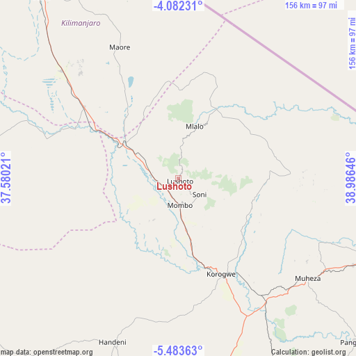
Lushoto GPS coordinates[2]
4° 46' 59.988" South, 38° 16' 59.988" East
| Map corner | latitude | longitude |
|---|---|---|
| Upper-left | -4.08231°, | 37.58021° |
| Center: | -4.78333°, | 38.28333° |
| Lower-right: | -5.48363°, | 38.98646° |
| Map W x H: | 155.8×155.8 km | = 96.8×96.8mi |
| max Lat: | -1.14389° ⇑40.2% North |
| Lushoto: | -4.78333° |
| min Lat: | ⇓59.8% South -11.36667° |
| min Long | Lushoto | max Long |
| 29.62667° | 38.28333° | 40.33333° |
| W 76.2%⇐ | ⇒23.8% E |
Elevation
Elevation of Lushoto is 1498 m = 4915 ft, and this is 555.2 m = 1822 ft above average elevation for this country.
| Max E: |
2377 m = 7799 ft | 16.4% |
| Lushoto | 1498 m 4915 ft | |
| Avg. | 942.8 m = 3093 ft | |
Min E: |
0 m = 0 ft | 83.6% |
See also: Tanzania elevation on elevation.city.
Geographical zone
Lushoto is located in South Torrid zone (between Equator and Tropic of Capricorn). Distance of Equator is 531.9 km =330.5 mi to North.| Distance of | km | miles | from Lushoto |
|---|---|---|---|
| Equator | 531.9 | 330.5 | to North |
| Tropic Capricorn | 2074.1 | 1288.8 | to South |
| Antarctic Circle | 6869.3 | 4268.4 | to South |
| South Pole | 9475.2 | 5887.6 | to South |


Nearby cities:
15 places around Lushoto: (largest is in red/bold)
• Chanika
76.4 km =47.5 mi,  202°
202°
• Hedaru
52.9 km =32.9 mi,  306°
306°
• Kihurio
42.6 km =26.5 mi,  325°
325°
• Kisiwani
81.2 km =50.5 mi, 332°
• Magomeni
53.3 km =33.1 mi, 200°
• Makanya
68.1 km =42.3 mi, 312°
• Makuyuni
21.1 km =13.1 mi,  285°
285°
• Maramba
47.4 km =29.5 mi,  128°
128°
• Matui
4.1 km =2.5 mi,  243°
243°
• Mazinde
7.6 km =4.7 mi,  255°
255°
• Mlalo
73.9 km =45.9 mi,  103°
103°
• Muheza
69.9 km =43.4 mi, 127°
• Mwanga
9.4 km =5.8 mi, 258°
• Ndungu
53.1 km =33 mi, 330°
• Soni
11.8 km =7.3 mi, 128°
Sources, notices
• [Note1] Compared only with cities in Tanzania existing in our database
• [Src1] Map data: © OpenStreetMap contributors (CC-BY-SA)
• [Src2] Other city data from geonames.org with taken over terms of usage.
• [Src3] Geographical zone / Annual Mean Temperature by Robert A. Rohde @ Wikipedia
