Ndungu geodata
Ndungu (Kilimanjaro) is a populated place; located in Tanzania in Africa/Dar_es_Salaam (GMT+3) time zone. With population of 14,545 people, there are 188 cities with bigger population in this country. Compared to other cities in Tanzania, 64.3% of cities are located further ↓South; 73.4% of cities are located further ←West and 68.2% of cities have higher elevation than Ndungu. Note1


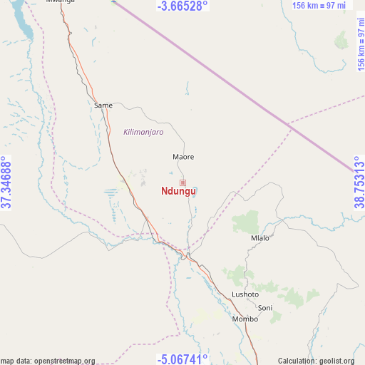
Ndungu GPS coordinates[2]
4° 22' 0.012" South, 38° 3' 0" East
| Map corner | latitude | longitude |
|---|---|---|
| Upper-left | -3.66528°, | 37.34688° |
| Center: | -4.36667°, | 38.05° |
| Lower-right: | -5.06741°, | 38.75313° |
| Map W x H: | 155.9×155.9 km | = 96.9×96.9mi |
| max Lat: | -1.14389° ⇑35.7% North |
| Ndungu: | -4.36667° |
| min Lat: | ⇓64.3% South -11.36667° |
| min Long | Ndungu | max Long |
| 29.62667° | 38.05° | 40.33333° |
| W 73.4%⇐ | ⇒26.6% E |
Elevation
Elevation of Ndungu is 535 m = 1755 ft, and this is 407.8 m = 1338 ft below average elevation for this country.
| Max E: |
2377 m = 7799 ft | 68.2% |
| Avg. | 942.8 m = 3093 ft | |
| Ndungu | 535 m = 1755 ft | |
Min E: |
0 m = 0 ft | 31.8% |
See also: Tanzania elevation on elevation.city.
Geographical zone
Ndungu is located in South Torrid zone (between Equator and Tropic of Capricorn). Distance of Equator is 485.5 km =301.7 mi to North.| Distance of | km | miles | from Ndungu |
|---|---|---|---|
| Equator | 485.5 | 301.7 | to North |
| Tropic Capricorn | 2120.4 | 1317.6 | to South |
| Antarctic Circle | 6915.6 | 4297.2 | to South |
| South Pole | 9521.5 | 5916.4 | to South |


Nearby cities:
15 places around Ndungu: (largest is in red/bold)
• Hedaru
22.3 km =13.9 mi,  228°
228°
• Kihurio
11.3 km =7 mi,  170°
170°
• Kirya
80.3 km =49.9 mi,  308°
308°
• Kisiwani
28.2 km =17.5 mi,  336°
336°
• Kwakoa
76.3 km =47.4 mi,  331°
331°
• Lembeni
80.7 km =50.1 mi,  323°
323°
• Lushoto
53.1 km =33 mi,  150°
150°
• Makanya
24 km =14.9 mi,  270°
270°
• Makuyuni
41.1 km =25.5 mi, 172°
• Matui
53 km =32.9 mi,  155°
155°
• Mazinde
51.6 km =32.1 mi, 159°
• Mwanga
51 km =31.7 mi, 160°
• Mwembe
32.7 km =20.3 mi, 317°
• Same
48.4 km =30.1 mi, 313°
• Soni
64.2 km =39.9 mi, 146°
Sources, notices
• [Note1] Compared only with cities in Tanzania existing in our database
• [Src1] Map data: © OpenStreetMap contributors (CC-BY-SA)
• [Src2] Other city data from geonames.org with taken over terms of usage.
• [Src3] Geographical zone / Annual Mean Temperature by Robert A. Rohde @ Wikipedia
