Kihangara geodata
Kihangara (Mwanza) is a populated place; located in Tanzania in Africa/Dar_es_Salaam (GMT+3) time zone. With population of 19,082 people, there are 137 cities with bigger population in this country. Compared to other cities in Tanzania, 89.9% of cities are located further ↓South; 75.9% of cities are located further →East and 60.1% of cities have lower elevation than Kihangara. Note1


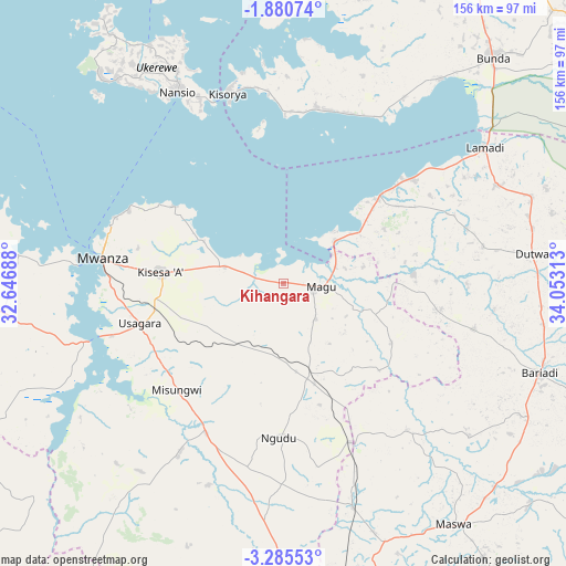
Kihangara GPS coordinates[2]
2° 34' 59.988" South, 33° 21' 0" East
| Map corner | latitude | longitude |
|---|---|---|
| Upper-left | -1.88074°, | 32.64688° |
| Center: | -2.58333°, | 33.35° |
| Lower-right: | -3.28553°, | 34.05313° |
| Map W x H: | 156.2×156.2 km | = 97.1×97.1mi |
| max Lat: | -1.14389° ⇑10.1% North |
| Kihangara: | -2.58333° |
| min Lat: | ⇓89.9% South -11.36667° |
| min Long | Kihangara | max Long |
| 29.62667° | 33.35° | 40.33333° |
| W 24.1%⇐ | ⇒75.9% E |
Elevation
Elevation of Kihangara is 1186 m = 3891 ft, and this is 243.2 m = 798 ft above average elevation for this country.
| Max E: |
2377 m = 7799 ft | 39.9% |
| Kihangara | 1186 m 3891 ft | |
| Avg. | 942.8 m = 3093 ft | |
Min E: |
0 m = 0 ft | 60.1% |
See also: Tanzania elevation on elevation.city.
Geographical zone
Kihangara is located in South Torrid zone (between Equator and Tropic of Capricorn). Distance of Equator is 287.2 km =178.5 mi to North.| Distance of | km | miles | from Kihangara |
|---|---|---|---|
| Equator | 287.2 | 178.5 | to North |
| Tropic Capricorn | 2318.7 | 1440.8 | to South |
| Antarctic Circle | 7113.9 | 4420.4 | to South |
| South Pole | 9719.8 | 6039.6 | to South |


Nearby cities:
15 places around Kihangara: (largest is in red/bold)
• Bariadi
74.4 km =46.2 mi,  108°
108°
• Kibara
49.4 km =30.7 mi,  12°
12°
• Malampaka
64.5 km =40.1 mi,  161°
161°
• Malya
48.2 km =30 mi, 157°
• Maswa
71.2 km =44.2 mi,  98°
98°
• Misasi
55 km =34.2 mi,  212°
212°
• Misungwi
41.9 km =26 mi,  224°
224°
• Mwanza
50.5 km =31.4 mi,  278°
278°
• Nakatunguru
60.7 km =37.7 mi,  328°
328°
• Nansio
60.1 km =37.3 mi, 326°
• Ngudu
42.7 km =26.5 mi,  182°
182°
• Nyakabindi
70.6 km =43.9 mi,  94°
94°
• Nyalikungu
82.3 km =51.1 mi,  144°
144°
• Nyanguge
17.1 km =10.6 mi, 282°
• Usagara
40.4 km =25.1 mi,  254°
254°
Sources, notices
• [Note1] Compared only with cities in Tanzania existing in our database
• [Src1] Map data: © OpenStreetMap contributors (CC-BY-SA)
• [Src2] Other city data from geonames.org with taken over terms of usage.
• [Src3] Geographical zone / Annual Mean Temperature by Robert A. Rohde @ Wikipedia
