Usagara geodata
Usagara (Mwanza) is a populated place; located in Tanzania in Africa/Dar_es_Salaam (GMT+3) time zone. With population of 15,514 people, there are 181 cities with bigger population in this country. Compared to other cities in Tanzania, 87.8% of cities are located further ↓South; 79.4% of cities are located further →East and 70.3% of cities have lower elevation than Usagara. Note1


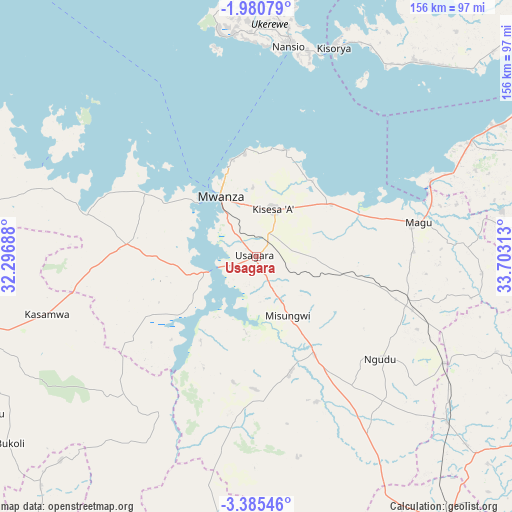
Usagara GPS coordinates[2]
2° 40' 59.988" South, 33° 0' 0" East
| Map corner | latitude | longitude |
|---|---|---|
| Upper-left | -1.98079°, | 32.29688° |
| Center: | -2.68333°, | 33° |
| Lower-right: | -3.38546°, | 33.70313° |
| Map W x H: | 156.2×156.2 km | = 97.1×97.1mi |
| max Lat: | -1.14389° ⇑12.2% North |
| Usagara: | -2.68333° |
| min Lat: | ⇓87.8% South -11.36667° |
| min Long | Usagara | max Long |
| 29.62667° | 33° | 40.33333° |
| W 20.6%⇐ | ⇒79.4% E |
Elevation
Elevation of Usagara is 1294 m = 4245 ft, and this is 351.2 m = 1152 ft above average elevation for this country.
| Max E: |
2377 m = 7799 ft | 29.7% |
| Usagara | 1294 m 4245 ft | |
| Avg. | 942.8 m = 3093 ft | |
Min E: |
0 m = 0 ft | 70.3% |
See also: Tanzania elevation on elevation.city.
Geographical zone
Usagara is located in South Torrid zone (between Equator and Tropic of Capricorn). Distance of Equator is 298.4 km =185.4 mi to North.| Distance of | km | miles | from Usagara |
|---|---|---|---|
| Equator | 298.4 | 185.4 | to North |
| Tropic Capricorn | 2307.6 | 1433.9 | to South |
| Antarctic Circle | 7102.8 | 4413.5 | to South |
| South Pole | 9708.7 | 6032.7 | to South |


Nearby cities:
15 places around Usagara: (largest is in red/bold)
• Bukonyo
81.9 km =50.9 mi,  354°
354°
• Kasamwa
65.6 km =40.8 mi,  253°
253°
• Kibara
77.6 km =48.2 mi,  40°
40°
• Kihangara
40.4 km =25.1 mi,  74°
74°
• Malampaka
77.5 km =48.2 mi,  130°
130°
• Malya
66.4 km =41.3 mi,  120°
120°
• Mhango
68.8 km =42.8 mi,  194°
194°
• Misasi
36.4 km =22.6 mi,  165°
165°
• Misungwi
20.7 km =12.9 mi,  153°
153°
• Muriti
78.4 km =48.7 mi, 353°
• Mwanza
21.6 km =13.4 mi,  329°
329°
• Nakatunguru
63.4 km =39.4 mi,  6°
6°
• Nansio
61.4 km =38.2 mi, 5°
• Ngudu
48.6 km =30.2 mi, 130°
• Nyanguge
26.7 km =16.6 mi,  56°
56°
Sources, notices
• [Note1] Compared only with cities in Tanzania existing in our database
• [Src1] Map data: © OpenStreetMap contributors (CC-BY-SA)
• [Src2] Other city data from geonames.org with taken over terms of usage.
• [Src3] Geographical zone / Annual Mean Temperature by Robert A. Rohde @ Wikipedia
