Misasi geodata
Misasi (Mwanza) is a populated place; located in Tanzania in Africa/Dar_es_Salaam (GMT+3) time zone. With population of 14,170 people, there are 189 cities with bigger population in this country. Compared to other cities in Tanzania, 84.3% of cities are located further ↓South; 78.3% of cities are located further →East and 54.2% of cities have lower elevation than Misasi. Note1


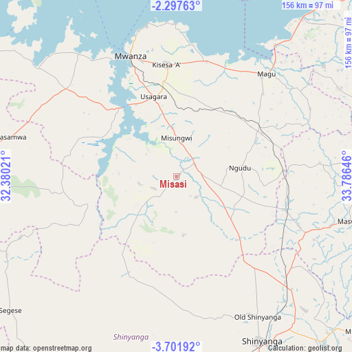
Misasi GPS coordinates[2]
3° 0' 0" South, 33° 4' 59.988" East
| Map corner | latitude | longitude |
|---|---|---|
| Upper-left | -2.29763°, | 32.38021° |
| Center: | -3°, | 33.08333° |
| Lower-right: | -3.70192°, | 33.78646° |
| Map W x H: | 156.1×156.1 km | = 97×97mi |
| max Lat: | -1.14389° ⇑15.7% North |
| Misasi: | -3° |
| min Lat: | ⇓84.3% South -11.36667° |
| min Long | Misasi | max Long |
| 29.62667° | 33.08333° | 40.33333° |
| W 21.7%⇐ | ⇒78.3% E |
Elevation
Elevation of Misasi is 1151 m = 3776 ft, and this is 208.2 m = 683 ft above average elevation for this country.
| Max E: |
2377 m = 7799 ft | 45.8% |
| Misasi | 1151 m 3776 ft | |
| Avg. | 942.8 m = 3093 ft | |
Min E: |
0 m = 0 ft | 54.2% |
See also: Tanzania elevation on elevation.city.
Geographical zone
Misasi is located in South Torrid zone (between Equator and Tropic of Capricorn). Distance of Equator is 333.6 km =207.3 mi to North.| Distance of | km | miles | from Misasi |
|---|---|---|---|
| Equator | 333.6 | 207.3 | to North |
| Tropic Capricorn | 2272.4 | 1412 | to South |
| Antarctic Circle | 7067.6 | 4391.6 | to South |
| South Pole | 9673.5 | 6010.8 | to South |


Nearby cities:
15 places around Misasi: (largest is in red/bold)
• Kasamwa
74.1 km =46 mi,  283°
283°
• Kihangara
55 km =34.2 mi,  32°
32°
• Malampaka
52.1 km =32.4 mi,  106°
106°
• Malya
48.2 km =30 mi,  87°
87°
• Mhango
40.8 km =25.4 mi,  219°
219°
• Misungwi
16.7 km =10.4 mi,  0°
0°
• Mwadui
83.8 km =52.1 mi,  136°
136°
• Mwanza
57.5 km =35.7 mi,  339°
339°
• Ngudu
28 km =17.4 mi,  82°
82°
• Nyalikungu
80.3 km =49.9 mi,  104°
104°
• Nyanguge
51.7 km =32.1 mi,  14°
14°
• Old Shinyanga
70.5 km =43.8 mi,  150°
150°
• Shinyanga
82.8 km =51.4 mi, 153°
• Songwa
74.9 km =46.5 mi, 140°
• Usagara
36.4 km =22.6 mi,  345°
345°
Sources, notices
• [Note1] Compared only with cities in Tanzania existing in our database
• [Src1] Map data: © OpenStreetMap contributors (CC-BY-SA)
• [Src2] Other city data from geonames.org with taken over terms of usage.
• [Src3] Geographical zone / Annual Mean Temperature by Robert A. Rohde @ Wikipedia
