Nyakabindi geodata
Nyakabindi (Simiyu) is a populated place; located in Tanzania in Africa/Dar_es_Salaam (GMT+3) time zone. With population of 18,428 people, there are 149 cities with bigger population in this country. Compared to other cities in Tanzania, 89.2% of cities are located further ↓South; 65% of cities are located further →East and 70.6% of cities have lower elevation than Nyakabindi. Note1


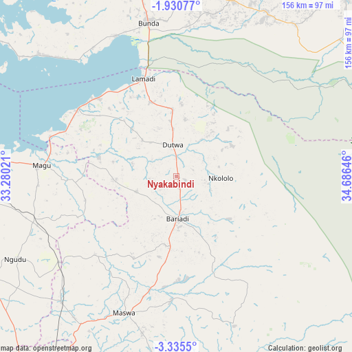
Nyakabindi GPS coordinates[2]
2° 37' 59.988" South, 33° 58' 59.988" East
| Map corner | latitude | longitude |
|---|---|---|
| Upper-left | -1.93077°, | 33.28021° |
| Center: | -2.63333°, | 33.98333° |
| Lower-right: | -3.3355°, | 34.68646° |
| Map W x H: | 156.2×156.2 km | = 97.1×97.1mi |
| max Lat: | -1.14389° ⇑10.8% North |
| Nyakabindi: | -2.63333° |
| min Lat: | ⇓89.2% South -11.36667° |
| min Long | Nyakabindi | max Long |
| 29.62667° | 33.98333° | 40.33333° |
| W 35%⇐ | ⇒65% E |
Elevation
Elevation of Nyakabindi is 1295 m = 4249 ft, and this is 352.2 m = 1156 ft above average elevation for this country.
| Max E: |
2377 m = 7799 ft | 29.4% |
| Nyakabindi | 1295 m 4249 ft | |
| Avg. | 942.8 m = 3093 ft | |
Min E: |
0 m = 0 ft | 70.6% |
See also: Tanzania elevation on elevation.city.
Geographical zone
Nyakabindi is located in South Torrid zone (between Equator and Tropic of Capricorn). Distance of Equator is 292.8 km =181.9 mi to North.| Distance of | km | miles | from Nyakabindi |
|---|---|---|---|
| Equator | 292.8 | 181.9 | to North |
| Tropic Capricorn | 2313.1 | 1437.3 | to South |
| Antarctic Circle | 7108.4 | 4417 | to South |
| South Pole | 9714.3 | 6036.2 | to South |


Nearby cities:
15 places around Nyakabindi: (largest is in red/bold)
• Bariadi
18.5 km =11.5 mi,  180°
180°
• Bunda
66.1 km =41.1 mi,  348°
348°
• Issenye
80.4 km =50 mi,  28°
28°
• Kibara
80 km =49.7 mi,  312°
312°
• Kihangara
70.6 km =43.9 mi,  274°
274°
• Kisesa
53.3 km =33.1 mi,  159°
159°
• Malampaka
74.8 km =46.5 mi,  221°
221°
• Malya
64.8 km =40.3 mi,  233°
233°
• Maswa
5.6 km =3.5 mi, 180°
• Matonga
29.9 km =18.6 mi,  21°
21°
• Ngudu
81.1 km =50.4 mi,  242°
242°
• Nyalikungu
65.1 km =40.5 mi,  199°
199°
• Nyamuswa
81.6 km =50.7 mi,  2°
2°
• Nyanguge
87.5 km =54.4 mi,  276°
276°
• Somanda
81.6 km =50.7 mi, 182°
Sources, notices
• [Note1] Compared only with cities in Tanzania existing in our database
• [Src1] Map data: © OpenStreetMap contributors (CC-BY-SA)
• [Src2] Other city data from geonames.org with taken over terms of usage.
• [Src3] Geographical zone / Annual Mean Temperature by Robert A. Rohde @ Wikipedia
