Zelyonoye geodata
Zelyonoye (Republic of Crimea) is a populated place; located in Ukraine in Europe/Simferopol (GMT+3) time zone. With population of 941 people, there are 1409 cities with bigger population in this country. Compared to other cities in Ukraine, 78% of cities are located further ↑North; 76.9% of cities are located further ←West and 88.6% of cities have higher elevation than Zelyonoye. Note1
Administrative division(s):
- Level 1: Republic of Crimea
- Level 2: Nizhnegorskiy rayon
- Level 3: Nizhnegorskoye sel'skoye poselenye


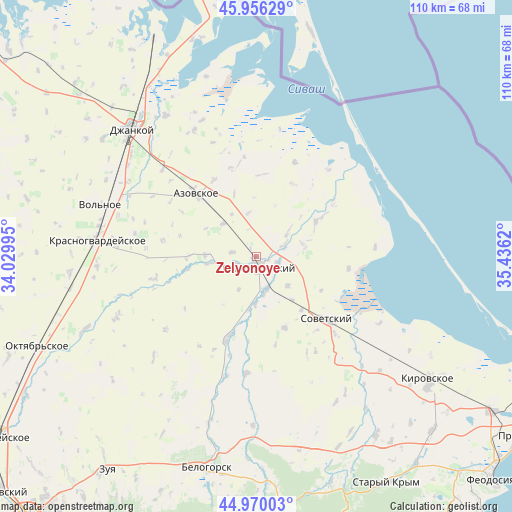
Zelyonoye GPS coordinates[2]
45° 27' 55.152" North, 34° 43' 59.052" East
| Map corner | latitude | longitude |
|---|---|---|
| Upper-left | 45.95629°, | 34.02995° |
| Center: | 45.46532°, | 34.73307° |
| Lower-right: | 44.97003°, | 35.4362° |
| Map W x H: | 109.7×109.7 km | = 68.2×68.2mi |
| max Lat: | 52.18903° ⇑78% North |
| Zelyonoye: | 45.46532° |
| min Lat: | ⇓22% South 44.39214° |
| min Long | Zelyonoye | max Long |
| 22.20555° | 34.73307° | 40.13222° |
| W 76.9%⇐ | ⇒23.1% E |
Elevation
Elevation of Zelyonoye is 21 m = 69 ft, and this is 134.8 m = 442 ft below average elevation for this country.
| Max E: |
886 m = 2907 ft | 88.6% |
| Avg. | 155.8 m = 511 ft | |
| Zelyonoye | 21 m = 69 ft | |
Min E: |
-3 m = -10 ft | 11.4% |
See also: Ukraine elevation on elevation.city.
Geographical zone
Zelyonoye is located in North temperate zone (between Tropic of Cancer and the Arctic Circle). Distance of this North polar circle is 2345.9 km =1457.7 mi to North.| Distance of | km | miles | from Zelyonoye |
|---|---|---|---|
| North Pole | 4951.8 | 3076.9 | to North |
| Arctic Circle | 2345.9 | 1457.7 | to North |
| Tropic Cancer | 2449.4 | 1522 | to South |
| Equator | 5055.3 | 3141.2 | to South |


Nearby cities:
15 places around Zelyonoye: (largest is in red/bold)
• Akimovka
9.3 km =5.8 mi,  49°
49°
• Chernozemnoye
9.3 km =5.8 mi,  133°
133°
• Ivanovka
10.2 km =6.3 mi,  185°
185°
• Listvennoye
6.3 km =3.9 mi,  74°
74°
• Lomonosovo
8 km =5 mi,  208°
208°
• Mikhaylovka
10.1 km =6.3 mi,  314°
314°
• Mitrofanovka
4.5 km =2.8 mi,  249°
249°
• Nizhnegorskiy
2 km =1.2 mi,  167°
167°
• Novoivanovka
5.2 km =3.2 mi,  98°
98°
• Plodovoye
2 km =1.2 mi, 210°
• Razlivy
1.1 km =0.7 mi,  244°
244°
• Semennoye
2.4 km =1.5 mi,  110°
110°
• Uvarovka
4.6 km =2.9 mi, 110°
• Zhelyabovka
7.6 km =4.7 mi, 165°
• Zorkino
9.3 km =5.8 mi,  349°
349°
Sources, notices
• [Note1] Compared only with cities in Ukraine existing in our database
• [Src1] Map data: © OpenStreetMap contributors (CC-BY-SA)
• [Src2] Other city data from geonames.org with taken over terms of usage.
• [Src3] Geographical zone / Annual Mean Temperature by Robert A. Rohde @ Wikipedia
