Zorkino geodata
Zorkino (Republic of Crimea) is a seat of a third-order administrative division; located in Ukraine in Europe/Simferopol (GMT+3) time zone. With population of 1,099 people, there are 1335 cities with bigger population in this country. Compared to other cities in Ukraine, 76.1% of cities are located further ↑North; 76.4% of cities are located further ←West and 93% of cities have higher elevation than Zorkino. Note1
Administrative division(s):
- Level 1: Republic of Crimea
- Level 2: Nizhnegorskiy rayon
- Level 3: Zorkinskoye sel'skoye poselenye


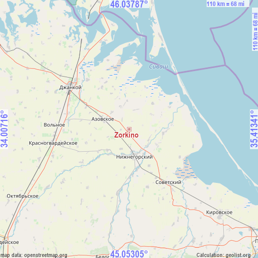
Zorkino GPS coordinates[2]
45° 32' 51.432" North, 34° 42' 37.008" East
| Map corner | latitude | longitude |
|---|---|---|
| Upper-left | 46.03787°, | 34.00716° |
| Center: | 45.54762°, | 34.71028° |
| Lower-right: | 45.05305°, | 35.41341° |
| Map W x H: | 109.5×109.5 km | = 68×68mi |
| max Lat: | 52.18903° ⇑76.1% North |
| Zorkino: | 45.54762° |
| min Lat: | ⇓23.9% South 44.39214° |
| min Long | Zorkino | max Long |
| 22.20555° | 34.71028° | 40.13222° |
| W 76.4%⇐ | ⇒23.6% E |
Elevation
Elevation of Zorkino is 15 m = 49 ft, and this is 140.8 m = 462 ft below average elevation for this country.
| Max E: |
886 m = 2907 ft | 93% |
| Avg. | 155.8 m = 511 ft | |
| Zorkino | 15 m = 49 ft | |
Min E: |
-3 m = -10 ft | 7% |
See also: Ukraine elevation on elevation.city.
Geographical zone
Zorkino is located in North temperate zone (between Tropic of Cancer and the Arctic Circle). Distance of this North polar circle is 2336.8 km =1452 mi to North.| Distance of | km | miles | from Zorkino |
|---|---|---|---|
| North Pole | 4942.6 | 3071.2 | to North |
| Arctic Circle | 2336.8 | 1452 | to North |
| Tropic Cancer | 2458.5 | 1527.6 | to South |
| Equator | 5064.4 | 3146.9 | to South |


Nearby cities:
15 places around Zorkino: (largest is in red/bold)
• Akimovka
9.4 km =5.8 mi,  109°
109°
• Azovskoye
12 km =7.5 mi,  290°
290°
• Borodino
10.8 km =6.7 mi,  349°
349°
• Chkalovo
11.5 km =7.1 mi,  56°
56°
• Listvennoye
10.8 km =6.7 mi,  133°
133°
• Mikhaylovka
5.8 km =3.6 mi,  248°
248°
• Mitrofanovka
11 km =6.8 mi,  192°
192°
• Nizhnegorskiy
11.3 km =7 mi,  168°
168°
• Novoivanovka
12.1 km =7.5 mi,  145°
145°
• Plodovoye
10.9 km =6.8 mi,  176°
176°
• Razlivy
9.7 km =6 mi, 175°
• Semennoye
10.8 km =6.7 mi,  158°
158°
• Svetloye
10.2 km =6.3 mi,  338°
338°
• Tabachnoye
10.4 km =6.5 mi,  314°
314°
• Zelyonoye
9.3 km =5.8 mi, 169°
Sources, notices
• [Note1] Compared only with cities in Ukraine existing in our database
• [Src1] Map data: © OpenStreetMap contributors (CC-BY-SA)
• [Src2] Other city data from geonames.org with taken over terms of usage.
• [Src3] Geographical zone / Annual Mean Temperature by Robert A. Rohde @ Wikipedia
