Kar’yernoye geodata
Kar’yernoye (Republic of Crimea) is a populated place; located in Ukraine in Europe/Simferopol (GMT+3) time zone. With population of 994 people, there are 1387 cities with bigger population in this country. Compared to other cities in Ukraine, 83% of cities are located further ↑North; 53.5% of cities are located further ←West and 83% of cities have higher elevation than Kar’yernoye. Note1
Administrative division(s):
- Level 1: Republic of Crimea
- Level 2: Sakskiy rayon
- Level 3: Okhotnikovskoye sel'skoye poselenye


Kar’yernoye GPS coordinates[2]
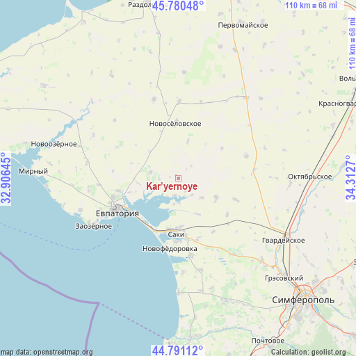
45° 17' 16.656" North, 33° 36' 34.452" East
| Map corner | latitude | longitude |
|---|---|---|
| Upper-left | 45.78048°, | 32.90645° |
| Center: | 45.28796°, | 33.60957° |
| Lower-right: | 44.79112°, | 34.3127° |
| Map W x H: | 110×110 km | = 68.4×68.4mi |
| max Lat: | 52.18903° ⇑83% North |
| Kar’yernoye: | 45.28796° |
| min Lat: | ⇓17% South 44.39214° |
| min Long | Kar’yernoye | max Long |
| 22.20555° | 33.60957° | 40.13222° |
| W 53.5%⇐ | ⇒46.5% E |
Elevation
Elevation of Kar’yernoye is 35 m = 115 ft, and this is 120.8 m = 396 ft below average elevation for this country.
| Max E: |
886 m = 2907 ft | 83% |
| Avg. | 155.8 m = 511 ft | |
| Kar’yernoye | 35 m = 115 ft | |
Min E: |
-3 m = -10 ft | 17% |
See also: Ukraine elevation on elevation.city.
Geographical zone
Kar’yernoye is located in North temperate zone (between Tropic of Cancer and the Arctic Circle). Distance of this North polar circle is 2365.6 km =1469.9 mi to North.| Distance of | km | miles | from Kar’yernoye |
|---|---|---|---|
| North Pole | 4971.5 | 3089.1 | to North |
| Arctic Circle | 2365.6 | 1469.9 | to North |
| Tropic Cancer | 2429.6 | 1509.7 | to South |
| Equator | 5035.5 | 3128.9 | to South |


Nearby cities:
15 places around Kar’yernoye: (largest is in red/bold)
• Dolinka
6.6 km =4.1 mi,  140°
140°
• Glinka
5.9 km =3.7 mi,  266°
266°
• Kamenolomnya
15.7 km =9.8 mi,  253°
253°
• Kol’tsovo
13.3 km =8.3 mi,  289°
289°
• Lesnovka
15 km =9.3 mi,  177°
177°
• Mityayevo
9.4 km =5.8 mi,  129°
129°
• Okhotnikovo
5.5 km =3.4 mi,  192°
192°
• Orlyanka
6.7 km =4.2 mi,  211°
211°
• Shelkovichnoye
12.8 km =8 mi,  151°
151°
• Stolbovoye
12.2 km =7.6 mi,  313°
313°
• Trudovoye
12.9 km =8 mi,  115°
115°
• Veresayevo
8.8 km =5.5 mi,  282°
282°
• Vinogradovo
12 km =7.5 mi,  13°
13°
• Vladimirovka
15.8 km =9.8 mi, 189°
• Zhuravli
4.7 km =2.9 mi, 148°
Sources, notices
• [Note1] Compared only with cities in Ukraine existing in our database
• [Src1] Map data: © OpenStreetMap contributors (CC-BY-SA)
• [Src2] Other city data from geonames.org with taken over terms of usage.
• [Src3] Geographical zone / Annual Mean Temperature by Robert A. Rohde @ Wikipedia
