Poshtove geodata
Poshtove (Republic of Crimea) is a seat of a third-order administrative division; located in Ukraine in Europe/Simferopol (GMT+3) time zone. With population of 3,086 people, there are 916 cities with bigger population in this country. Compared to other cities in Ukraine, 94.8% of cities are located further ↑North; 61.6% of cities are located further ←West and 65.3% of cities have lower elevation than Poshtove. Note1
Administrative division(s):
- Level 1: Republic of Crimea
- Level 2: Bakhchysarai Raion
- Level 3: Pochtovskoye sel'skoye poselenye


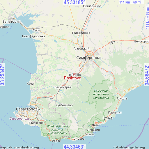
Poshtove GPS coordinates[2]
44° 50' 7.44" North, 33° 57' 41.724" East
| Map corner | latitude | longitude |
|---|---|---|
| Upper-left | 45.33185°, | 33.25847° |
| Center: | 44.8354°, | 33.96159° |
| Lower-right: | 44.33463°, | 34.66472° |
| Map W x H: | 110.9×110.9 km | = 68.9×68.9mi |
| max Lat: | 52.18903° ⇑94.8% North |
| Poshtove: | 44.8354° |
| min Lat: | ⇓5.2% South 44.39214° |
| min Long | Poshtove | max Long |
| 22.20555° | 33.96159° | 40.13222° |
| W 61.6%⇐ | ⇒38.4% E |
Elevation
Elevation of Poshtove is 186 m = 610 ft, and this is 30.2 m = 99 ft above average elevation for this country.
| Max E: |
886 m = 2907 ft | 34.7% |
| Poshtove | 186 m 610 ft | |
| Avg. | 155.8 m = 511 ft | |
Min E: |
-3 m = -10 ft | 65.3% |
See also: Ukraine elevation on elevation.city.
Geographical zone
Poshtove is located in North temperate zone (between Tropic of Cancer and the Arctic Circle). Distance of this Northern Tropic circle is 2379.3 km =1478.4 mi to South.| Distance of | km | miles | from Poshtove |
|---|---|---|---|
| North Pole | 5021.8 | 3120.4 | to North |
| Arctic Circle | 2415.9 | 1501.2 | to North |
| Tropic Cancer | 2379.3 | 1478.4 | to South |
| Equator | 4985.2 | 3097.7 | to South |


Nearby cities:
15 places around Poshtove: (largest is in red/bold)
• Aromatnoye
8 km =5 mi,  243°
243°
• Chisten’koye
8.5 km =5.3 mi,  52°
52°
• Glubokiy Yar
6.1 km =3.8 mi,  216°
216°
• Kashtanovoye
7.7 km =4.8 mi,  92°
92°
• Kizilovoye
6.7 km =4.2 mi,  105°
105°
• Levadki
7.5 km =4.7 mi,  58°
58°
• Novopavlovka
1.4 km =0.9 mi,  181°
181°
• Novovasilyevka
3.9 km =2.4 mi,  292°
292°
• Prokhladnoye
9.1 km =5.7 mi,  164°
164°
• Samokhvalovo
3.4 km =2.1 mi,  249°
249°
• Sevastyanovka
2.8 km =1.7 mi,  232°
232°
• Skalistoye
2.4 km =1.5 mi,  148°
148°
• Topoli
2.8 km =1.7 mi,  74°
74°
• Trekhprudnoye
8.8 km =5.5 mi,  34°
34°
• Trudolyubovka
5.9 km =3.7 mi, 154°
Sources, notices
• [Note1] Compared only with cities in Ukraine existing in our database
• [Src1] Map data: © OpenStreetMap contributors (CC-BY-SA)
• [Src2] Other city data from geonames.org with taken over terms of usage.
• [Src3] Geographical zone / Annual Mean Temperature by Robert A. Rohde @ Wikipedia
