Hlevakha geodata
Hlevakha (Kyiv) is a populated place; located in Ukraine in Europe/Kiev (GMT+3) time zone. With population of 8,835 people, there are 406 cities with bigger population in this country. Compared to other cities in Ukraine, 87.5% of cities are located further ↓South; 66% of cities are located further →East and 65.7% of cities have lower elevation than Hlevakha. Note1


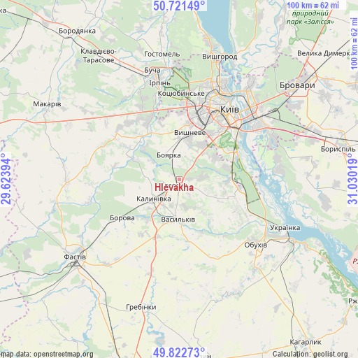
Hlevakha GPS coordinates[2]
50° 16' 27.228" North, 30° 19' 37.416" East
| Map corner | latitude | longitude |
|---|---|---|
| Upper-left | 50.72149°, | 29.62394° |
| Center: | 50.27423°, | 30.32706° |
| Lower-right: | 49.82273°, | 31.03019° |
| Map W x H: | 99.9×99.9 km | = 62.1×62.1mi |
| max Lat: | 52.18903° ⇑12.5% North |
| Hlevakha: | 50.27423° |
| min Lat: | ⇓87.5% South 44.39214° |
| min Long | Hlevakha | max Long |
| 22.20555° | 30.32706° | 40.13222° |
| W 34%⇐ | ⇒66% E |
Elevation
Elevation of Hlevakha is 188 m = 617 ft, and this is 32.2 m = 106 ft above average elevation for this country.
| Max E: |
886 m = 2907 ft | 34.3% |
| Hlevakha | 188 m 617 ft | |
| Avg. | 155.8 m = 511 ft | |
Min E: |
-3 m = -10 ft | 65.7% |
See also: Ukraine elevation on elevation.city.
Geographical zone
Hlevakha is located in North temperate zone (between Tropic of Cancer and the Arctic Circle). Distance of this North polar circle is 1811.2 km =1125.4 mi to North.| Distance of | km | miles | from Hlevakha |
|---|---|---|---|
| North Pole | 4417.1 | 2744.7 | to North |
| Arctic Circle | 1811.2 | 1125.4 | to North |
| Tropic Cancer | 2984.1 | 1854.2 | to South |
| Equator | 5590 | 3473.5 | to South |


Nearby cities:
15 places around Hlevakha: (largest is in red/bold)
• Bobrytsya
12.9 km =8 mi,  310°
310°
• Borova
19.2 km =11.9 mi,  235°
235°
• Boyarka
5.4 km =3.4 mi,  337°
337°
• Chabany
10.1 km =6.3 mi,  42°
42°
• Hnidyn
27.9 km =17.3 mi,  77°
77°
• Khotiv
11.8 km =7.3 mi,  57°
57°
• Kotsyubyns’ke
23.8 km =14.8 mi,  0°
0°
• Kriukivschina
11.2 km =7 mi,  15°
15°
• Kyiv
24.4 km =15.2 mi,  34°
34°
• Motovylivka
22.1 km =13.7 mi,  234°
234°
• Obukhiv
27.9 km =17.3 mi,  131°
131°
• Sofiyivska Borschagivka
15.4 km =9.6 mi,  10°
10°
• Vasylkiv
9.8 km =6.1 mi,  185°
185°
• Vyshneve
13.1 km =8.1 mi, 13°
• Yasnohorodka
23.5 km =14.6 mi,  292°
292°
Sources, notices
• [Note1] Compared only with cities in Ukraine existing in our database
• [Src1] Map data: © OpenStreetMap contributors (CC-BY-SA)
• [Src2] Other city data from geonames.org with taken over terms of usage.
• [Src3] Geographical zone / Annual Mean Temperature by Robert A. Rohde @ Wikipedia
