Starobesheve geodata
Starobesheve (Donetsk) is a seat of a second-order administrative division; located in Ukraine in Europe/Kiev (GMT+3) time zone. With population of 6,917 people, there are 514 cities with bigger population in this country. Compared to other cities in Ukraine, 58.9% of cities are located further ↑North; 94.6% of cities are located further ←West and 52.7% of cities have higher elevation than Starobesheve. Note1


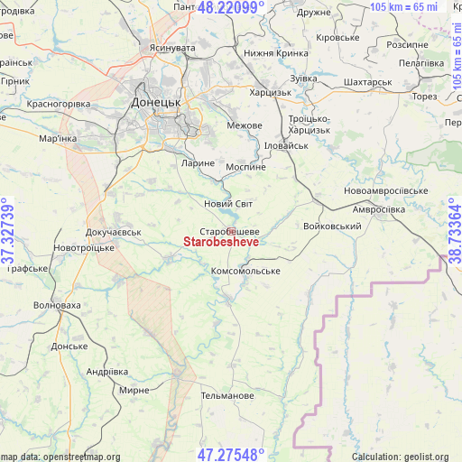
Starobesheve GPS coordinates[2]
47° 45' 1.368" North, 38° 1' 49.836" East
| Map corner | latitude | longitude |
|---|---|---|
| Upper-left | 48.22099°, | 37.32739° |
| Center: | 47.75038°, | 38.03051° |
| Lower-right: | 47.27548°, | 38.73364° |
| Map W x H: | 105.1×105.1 km | = 65.3×65.3mi |
| max Lat: | 52.18903° ⇑58.9% North |
| Starobesheve: | 47.75038° |
| min Lat: | ⇓41.1% South 44.39214° |
| min Long | Starobesheve | max Long |
| 22.20555° | 38.03051° | 40.13222° |
| W 94.6%⇐ | ⇒5.4% E |
Elevation
Elevation of Starobesheve is 126 m = 413 ft, and this is 29.8 m = 98 ft below average elevation for this country.
| Max E: |
886 m = 2907 ft | 52.7% |
| Avg. | 155.8 m = 511 ft | |
| Starobesheve | 126 m = 413 ft | |
Min E: |
-3 m = -10 ft | 47.3% |
See also: Ukraine elevation on elevation.city.
Geographical zone
Starobesheve is located in North temperate zone (between Tropic of Cancer and the Arctic Circle). Distance of this North polar circle is 2091.8 km =1299.8 mi to North.| Distance of | km | miles | from Starobesheve |
|---|---|---|---|
| North Pole | 4697.7 | 2919 | to North |
| Arctic Circle | 2091.8 | 1299.8 | to North |
| Tropic Cancer | 2703.4 | 1679.8 | to South |
| Equator | 5309.3 | 3299 | to South |


Nearby cities:
15 places around Starobesheve: (largest is in red/bold)
• Amvrosiyivka
33.8 km =21 mi,  81°
81°
• Dokuchayevs’k
26.3 km =16.3 mi,  270°
270°
• Donetsk
34.8 km =21.6 mi,  330°
330°
• Horbachevo-Mykhaylivka
11.4 km =7.1 mi,  350°
350°
• Ilovays’k
23.3 km =14.5 mi,  33°
33°
• Khartsyz’k
33.6 km =20.9 mi,  15°
15°
• Kuteynykove
20.4 km =12.7 mi,  70°
70°
• Makiyivka
34 km =21.1 mi, 346°
• Mospyne
15.8 km =9.8 mi,  9°
9°
• Novyy Svit
6.2 km =3.9 mi, 353°
• P'yatypill'ya
30 km =18.6 mi, 9°
• Shakhtne
32 km =19.9 mi,  35°
35°
• Shyroke
27.4 km =17 mi, 33°
• Vysoke
21.6 km =13.4 mi, 5°
• Zuhres
33.9 km =21.1 mi, 31°
Sources, notices
• [Note1] Compared only with cities in Ukraine existing in our database
• [Src1] Map data: © OpenStreetMap contributors (CC-BY-SA)
• [Src2] Other city data from geonames.org with taken over terms of usage.
• [Src3] Geographical zone / Annual Mean Temperature by Robert A. Rohde @ Wikipedia
