Ilovays’k geodata
Ilovays’k (Donetsk) is a populated place; located in Ukraine in Europe/Kiev (GMT+3) time zone. With population of 17,621 people, there are 221 cities with bigger population in this country. Compared to other cities in Ukraine, 57.6% of cities are located further ↑North; 95.5% of cities are located further ←West and 67.1% of cities have lower elevation than Ilovays’k. Note1


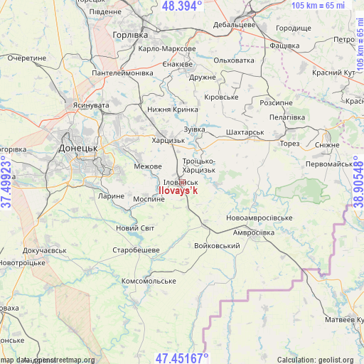
Ilovays’k GPS coordinates[2]
47° 55' 29.928" North, 38° 12' 8.46" East
| Map corner | latitude | longitude |
|---|---|---|
| Upper-left | 48.394°, | 37.49923° |
| Center: | 47.92498°, | 38.20235° |
| Lower-right: | 47.45167°, | 38.90548° |
| Map W x H: | 104.8×104.8 km | = 65.1×65.1mi |
| max Lat: | 52.18903° ⇑57.6% North |
| Ilovays’k: | 47.92498° |
| min Lat: | ⇓42.4% South 44.39214° |
| min Long | Ilovays’k | max Long |
| 22.20555° | 38.20235° | 40.13222° |
| W 95.5%⇐ | ⇒4.5% E |
Elevation
Elevation of Ilovays’k is 194 m = 636 ft, and this is 38.2 m = 125 ft above average elevation for this country.
| Max E: |
886 m = 2907 ft | 32.9% |
| Ilovays’k | 194 m 636 ft | |
| Avg. | 155.8 m = 511 ft | |
Min E: |
-3 m = -10 ft | 67.1% |
See also: Ukraine elevation on elevation.city.
Geographical zone
Ilovays’k is located in North temperate zone (between Tropic of Cancer and the Arctic Circle). Distance of this North polar circle is 2072.4 km =1287.7 mi to North.| Distance of | km | miles | from Ilovays’k |
|---|---|---|---|
| North Pole | 4678.3 | 2907 | to North |
| Arctic Circle | 2072.4 | 1287.7 | to North |
| Tropic Cancer | 2722.8 | 1691.9 | to South |
| Equator | 5328.8 | 3311.2 | to South |


Nearby cities:
15 places around Ilovays’k: (largest is in red/bold)
• Blahodatne
21.7 km =13.5 mi,  103°
103°
• Horbachevo-Mykhaylivka
16.8 km =10.4 mi,  240°
240°
• Khartsyz’k
13.7 km =8.5 mi,  342°
342°
• Kuteynykove
14.1 km =8.8 mi,  152°
152°
• Makiyivka
24.7 km =15.3 mi,  303°
303°
• Mospyne
11 km =6.8 mi,  249°
249°
• Novyy Svit
18.9 km =11.7 mi,  225°
225°
• Nyzhnya Krynka
21.2 km =13.2 mi,  351°
351°
• P'yatypill'ya
12.7 km =7.9 mi,  322°
322°
• Shakhtars’k
22.9 km =14.2 mi,  50°
50°
• Shakhtne
8.8 km =5.5 mi,  42°
42°
• Shyroke
4.2 km =2.6 mi,  31°
31°
• Starobesheve
23.3 km =14.5 mi,  213°
213°
• Vysoke
11 km =6.8 mi,  281°
281°
• Zuhres
10.7 km =6.6 mi, 25°
Sources, notices
• [Note1] Compared only with cities in Ukraine existing in our database
• [Src1] Map data: © OpenStreetMap contributors (CC-BY-SA)
• [Src2] Other city data from geonames.org with taken over terms of usage.
• [Src3] Geographical zone / Annual Mean Temperature by Robert A. Rohde @ Wikipedia
