Amvrosiyivka geodata
Amvrosiyivka (Donetsk) is a seat of a second-order administrative division; located in Ukraine in Europe/Kiev (GMT+3) time zone. With population of 21,307 people, there are 192 cities with bigger population in this country. Compared to other cities in Ukraine, 58.7% of cities are located further ↑North; 96.5% of cities are located further ←West and 51.9% of cities have lower elevation than Amvrosiyivka. Note1


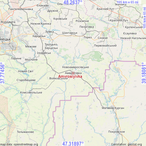
Amvrosiyivka GPS coordinates[2]
47° 47' 36.528" North, 38° 28' 39.648" East
| Map corner | latitude | longitude |
|---|---|---|
| Upper-left | 48.2637°, | 37.77456° |
| Center: | 47.79348°, | 38.47768° |
| Lower-right: | 47.31897°, | 39.18081° |
| Map W x H: | 105×105 km | = 65.2×65.2mi |
| max Lat: | 52.18903° ⇑58.7% North |
| Amvrosiyivka: | 47.79348° |
| min Lat: | ⇓41.3% South 44.39214° |
| min Long | Amvrosiyivka | max Long |
| 22.20555° | 38.47768° | 40.13222° |
| W 96.5%⇐ | ⇒3.5% E |
Elevation
Elevation of Amvrosiyivka is 141 m = 463 ft, and this is 14.8 m = 49 ft below average elevation for this country.
| Max E: |
886 m = 2907 ft | 48.1% |
| Avg. | 155.8 m = 511 ft | |
| Amvrosiyivka | 141 m = 463 ft | |
Min E: |
-3 m = -10 ft | 51.9% |
See also: Ukraine elevation on elevation.city.
Geographical zone
Amvrosiyivka is located in North temperate zone (between Tropic of Cancer and the Arctic Circle). Distance of this North polar circle is 2087 km =1296.8 mi to North.| Distance of | km | miles | from Amvrosiyivka |
|---|---|---|---|
| North Pole | 4692.9 | 2916 | to North |
| Arctic Circle | 2087 | 1296.8 | to North |
| Tropic Cancer | 2708.2 | 1682.8 | to South |
| Equator | 5314.1 | 3302 | to South |


Nearby cities:
15 places around Amvrosiyivka: (largest is in red/bold)
• Blahodatne
9.6 km =6 mi,  3°
3°
• Chystyakove
28.7 km =17.8 mi,  18°
18°
• Horbachevo-Mykhaylivka
35.8 km =22.2 mi,  280°
280°
• Ilovays’k
25.2 km =15.7 mi,  305°
305°
• Kuteynykove
14.3 km =8.9 mi, 278°
• Mospyne
32.7 km =20.3 mi,  289°
289°
• Novyy Svit
34.1 km =21.2 mi,  272°
272°
• Shakhtars’k
29.4 km =18.3 mi,  354°
354°
• Shakhtne
25.7 km =16 mi,  325°
325°
• Shyroke
25.8 km =16 mi, 314°
• Snizhne
33.9 km =21.1 mi,  40°
40°
• Starobesheve
33.8 km =21 mi,  261°
261°
• Stizhkivs’ke
35.6 km =22.1 mi, 1°
• Vysoke
35.5 km =22.1 mi,  298°
298°
• Zuhres
29 km =18 mi, 326°
Sources, notices
• [Note1] Compared only with cities in Ukraine existing in our database
• [Src1] Map data: © OpenStreetMap contributors (CC-BY-SA)
• [Src2] Other city data from geonames.org with taken over terms of usage.
• [Src3] Geographical zone / Annual Mean Temperature by Robert A. Rohde @ Wikipedia
