Slatyne geodata
Slatyne (Kharkiv) is a populated place; located in Ukraine in Europe/Kiev (GMT+3) time zone. With population of 6,544 people, there are 537 cities with bigger population in this country. Compared to other cities in Ukraine, 86.6% of cities are located further ↓South; 87.8% of cities are located further ←West and 50.5% of cities have higher elevation than Slatyne. Note1


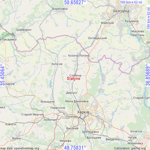
Slatyne GPS coordinates[2]
50° 12' 37.476" North, 36° 9' 13.536" East
| Map corner | latitude | longitude |
|---|---|---|
| Upper-left | 50.65827°, | 35.45064° |
| Center: | 50.21041°, | 36.15376° |
| Lower-right: | 49.75831°, | 36.85689° |
| Map W x H: | 100.1×100.1 km | = 62.2×62.2mi |
| max Lat: | 52.18903° ⇑13.4% North |
| Slatyne: | 50.21041° |
| min Lat: | ⇓86.6% South 44.39214° |
| min Long | Slatyne | max Long |
| 22.20555° | 36.15376° | 40.13222° |
| W 87.8%⇐ | ⇒12.2% E |
Elevation
Elevation of Slatyne is 132 m = 433 ft, and this is 23.8 m = 78 ft below average elevation for this country.
| Max E: |
886 m = 2907 ft | 50.5% |
| Avg. | 155.8 m = 511 ft | |
| Slatyne | 132 m = 433 ft | |
Min E: |
-3 m = -10 ft | 49.5% |
See also: Ukraine elevation on elevation.city.
Geographical zone
Slatyne is located in North temperate zone (between Tropic of Cancer and the Arctic Circle). Distance of this North polar circle is 1818.3 km =1129.8 mi to North.| Distance of | km | miles | from Slatyne |
|---|---|---|---|
| North Pole | 4424.2 | 2749.1 | to North |
| Arctic Circle | 1818.3 | 1129.8 | to North |
| Tropic Cancer | 2977 | 1849.8 | to South |
| Equator | 5582.9 | 3469.1 | to South |


Nearby cities:
15 places around Slatyne: (largest is in red/bold)
• Budy
36.7 km =22.8 mi,  194°
194°
• Derhachi
11.8 km =7.3 mi, 191°
• Kharkiv
26.5 km =16.5 mi,  164°
164°
• Korotych
30.4 km =18.9 mi,  195°
195°
• Kulynychi
30.2 km =18.8 mi,  147°
147°
• Lyubotyn
33.4 km =20.8 mi,  208°
208°
• Mala Danylivka
16.4 km =10.2 mi,  177°
177°
• Manchenky
33.2 km =20.6 mi,  219°
219°
• Peresichna
24.1 km =15 mi, 211°
• Pivdenne
36.9 km =22.9 mi, 189°
• Pokotylivka
33.1 km =20.6 mi, 177°
• Prudyanka
3 km =1.9 mi,  19°
19°
• Solonytsivka
25.2 km =15.7 mi, 199°
• Vysokyy
35.5 km =22.1 mi, 183°
• Zolochiv
14.5 km =9 mi,  302°
302°
Sources, notices
• [Note1] Compared only with cities in Ukraine existing in our database
• [Src1] Map data: © OpenStreetMap contributors (CC-BY-SA)
• [Src2] Other city data from geonames.org with taken over terms of usage.
• [Src3] Geographical zone / Annual Mean Temperature by Robert A. Rohde @ Wikipedia
