Zolochiv geodata
Zolochiv (Kharkiv) is a seat of a second-order administrative division; located in Ukraine in Europe/Kiev (GMT+3) time zone. With population of 11,160 people, there are 324 cities with bigger population in this country. Compared to other cities in Ukraine, 87.6% of cities are located further ↓South; 86.8% of cities are located further ←West and 51.5% of cities have lower elevation than Zolochiv. Note1


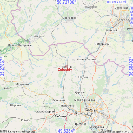
Zolochiv GPS coordinates[2]
50° 16' 47.46" North, 35° 58' 54.444" East
| Map corner | latitude | longitude |
|---|---|---|
| Upper-left | 50.72706°, | 35.27867° |
| Center: | 50.27985°, | 35.98179° |
| Lower-right: | 49.8284°, | 36.68492° |
| Map W x H: | 99.9×99.9 km | = 62.1×62.1mi |
| max Lat: | 52.18903° ⇑12.4% North |
| Zolochiv: | 50.27985° |
| min Lat: | ⇓87.6% South 44.39214° |
| min Long | Zolochiv | max Long |
| 22.20555° | 35.98179° | 40.13222° |
| W 86.8%⇐ | ⇒13.2% E |
Elevation
Elevation of Zolochiv is 140 m = 459 ft, and this is 15.8 m = 52 ft below average elevation for this country.
| Max E: |
886 m = 2907 ft | 48.5% |
| Avg. | 155.8 m = 511 ft | |
| Zolochiv | 140 m = 459 ft | |
Min E: |
-3 m = -10 ft | 51.5% |
See also: Ukraine elevation on elevation.city.
Geographical zone
Zolochiv is located in North temperate zone (between Tropic of Cancer and the Arctic Circle). Distance of this North polar circle is 1810.6 km =1125.1 mi to North.| Distance of | km | miles | from Zolochiv |
|---|---|---|---|
| North Pole | 4416.5 | 2744.3 | to North |
| Arctic Circle | 1810.6 | 1125.1 | to North |
| Tropic Cancer | 2984.7 | 1854.6 | to South |
| Equator | 5590.6 | 3473.8 | to South |


Nearby cities:
15 places around Zolochiv: (largest is in red/bold)
• Bohodukhiv
34.8 km =21.6 mi,  248°
248°
• Derhachi
21.7 km =13.5 mi,  152°
152°
• Kharkiv
38.5 km =23.9 mi, 149°
• Korotych
37.2 km =23.1 mi,  173°
173°
• Lyubotyn
37.2 km =23.1 mi,  185°
185°
• Mala Danylivka
27.4 km =17 mi, 151°
• Manchenky
34.5 km =21.4 mi, 194°
• Peresichna
28.4 km =17.6 mi,  180°
180°
• Pokotylivka
43 km =26.7 mi,  161°
161°
• Prudyanka
14.1 km =8.8 mi,  110°
110°
• Shlyakh
42.5 km =26.4 mi,  201°
201°
• Slatyne
14.5 km =9 mi,  122°
122°
• Solonytsivka
31.7 km =19.7 mi, 173°
• Staryy Merchyk
36.8 km =22.9 mi,  205°
205°
• Velyka Pysarivka
39.1 km =24.3 mi,  294°
294°
Sources, notices
• [Note1] Compared only with cities in Ukraine existing in our database
• [Src1] Map data: © OpenStreetMap contributors (CC-BY-SA)
• [Src2] Other city data from geonames.org with taken over terms of usage.
• [Src3] Geographical zone / Annual Mean Temperature by Robert A. Rohde @ Wikipedia
