Rusakovka geodata
Rusakovka (Republic of Crimea) is a seat of a third-order administrative division; located in Ukraine in Europe/Simferopol (GMT+3) time zone. With population of 918 people, there are 1422 cities with bigger population in this country. Compared to other cities in Ukraine, 87.6% of cities are located further ↑North; 73% of cities are located further ←West and 78.3% of cities have lower elevation than Rusakovka. Note1
Administrative division(s):
- Level 1: Republic of Crimea
- Level 2: Belogorskiy rayon
- Level 3: Rusakovskoye sel'skoye poselenye


Rusakovka GPS coordinates[2]
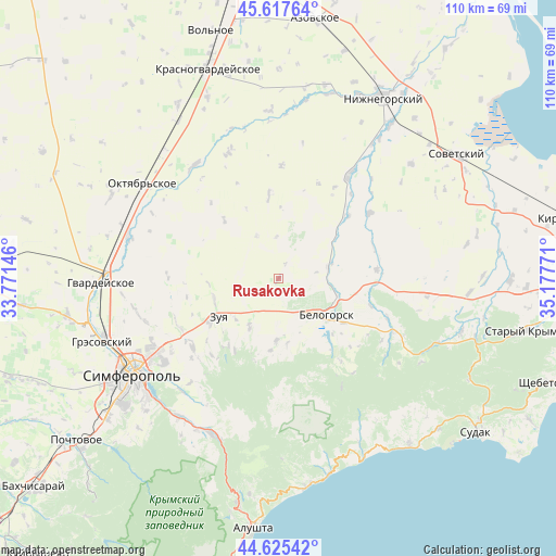
45° 7' 25.284" North, 34° 28' 28.488" East
| Map corner | latitude | longitude |
|---|---|---|
| Upper-left | 45.61764°, | 33.77146° |
| Center: | 45.12369°, | 34.47458° |
| Lower-right: | 44.62542°, | 35.17771° |
| Map W x H: | 110.3×110.3 km | = 68.5×68.5mi |
| max Lat: | 52.18903° ⇑87.6% North |
| Rusakovka: | 45.12369° |
| min Lat: | ⇓12.4% South 44.39214° |
| min Long | Rusakovka | max Long |
| 22.20555° | 34.47458° | 40.13222° |
| W 73%⇐ | ⇒27% E |
Elevation
Elevation of Rusakovka is 240 m = 787 ft, and this is 84.2 m = 276 ft above average elevation for this country.
| Max E: |
886 m = 2907 ft | 21.7% |
| Rusakovka | 240 m 787 ft | |
| Avg. | 155.8 m = 511 ft | |
Min E: |
-3 m = -10 ft | 78.3% |
See also: Ukraine elevation on elevation.city.
Geographical zone
Rusakovka is located in North temperate zone (between Tropic of Cancer and the Arctic Circle). Distance of this North polar circle is 2383.9 km =1481.3 mi to North.| Distance of | km | miles | from Rusakovka |
|---|---|---|---|
| North Pole | 4989.8 | 3100.5 | to North |
| Arctic Circle | 2383.9 | 1481.3 | to North |
| Tropic Cancer | 2411.4 | 1498.4 | to South |
| Equator | 5017.3 | 3117.6 | to South |


Nearby cities:
15 places around Rusakovka: (largest is in red/bold)
• Aleksandrovka
11.7 km =7.3 mi,  158°
158°
• Aromatnoye
11.3 km =7 mi,  211°
211°
• Balki
14.5 km =9 mi,  186°
186°
• Belaya Skala
12.1 km =7.5 mi,  106°
106°
• Bilohirsk
12.6 km =7.8 mi,  127°
127°
• Dolinovka
7.5 km =4.7 mi,  283°
283°
• Krinichnoye
15.4 km =9.6 mi,  135°
135°
• Krymskaya Roza
11.8 km =7.3 mi,  231°
231°
• Litvinenkovo
13.5 km =8.4 mi,  252°
252°
• Mel’nichnoye
9.4 km =5.8 mi,  332°
332°
• Novoklyonovo
13.1 km =8.1 mi,  172°
172°
• Tsvetochnoye
8.1 km =5 mi,  239°
239°
• Vishennoye
9.9 km =6.2 mi,  76°
76°
• Zelenogorskoye
12.4 km =7.7 mi,  182°
182°
• Zuya
14.3 km =8.9 mi, 237°
Sources, notices
• [Note1] Compared only with cities in Ukraine existing in our database
• [Src1] Map data: © OpenStreetMap contributors (CC-BY-SA)
• [Src2] Other city data from geonames.org with taken over terms of usage.
• [Src3] Geographical zone / Annual Mean Temperature by Robert A. Rohde @ Wikipedia
