Mel’nichnoye geodata
Mel’nichnoye (Republic of Crimea) is a seat of a third-order administrative division; located in Ukraine in Europe/Simferopol (GMT+3) time zone. With population of 746 people, there are 1512 cities with bigger population in this country. Compared to other cities in Ukraine, 85.9% of cities are located further ↑North; 72.4% of cities are located further ←West and 56.8% of cities have lower elevation than Mel’nichnoye. Note1
Administrative division(s):
- Level 1: Republic of Crimea
- Level 2: Belogorskiy rayon
- Level 3: Mel'nichnoye sel'skoye poselenye


Mel’nichnoye GPS coordinates[2]
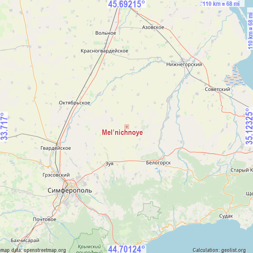
45° 11' 55.86" North, 34° 25' 12.432" East
| Map corner | latitude | longitude |
|---|---|---|
| Upper-left | 45.69215°, | 33.717° |
| Center: | 45.19885°, | 34.42012° |
| Lower-right: | 44.70124°, | 35.12325° |
| Map W x H: | 110.2×110.2 km | = 68.5×68.5mi |
| max Lat: | 52.18903° ⇑85.9% North |
| Mel’nichnoye: | 45.19885° |
| min Lat: | ⇓14.1% South 44.39214° |
| min Long | Mel’nichnoye | max Long |
| 22.20555° | 34.42012° | 40.13222° |
| W 72.4%⇐ | ⇒27.6% E |
Elevation
Elevation of Mel’nichnoye is 158 m = 518 ft, and this is 2.2 m = 7 ft above average elevation for this country.
| Max E: |
886 m = 2907 ft | 43.2% |
| Mel’nichnoye | 158 m 518 ft | |
| Avg. | 155.8 m = 511 ft | |
Min E: |
-3 m = -10 ft | 56.8% |
See also: Ukraine elevation on elevation.city.
Geographical zone
Mel’nichnoye is located in North temperate zone (between Tropic of Cancer and the Arctic Circle). Distance of this North polar circle is 2375.5 km =1476.1 mi to North.| Distance of | km | miles | from Mel’nichnoye |
|---|---|---|---|
| North Pole | 4981.4 | 3095.3 | to North |
| Arctic Circle | 2375.5 | 1476.1 | to North |
| Tropic Cancer | 2419.7 | 1503.5 | to South |
| Equator | 5025.6 | 3122.8 | to South |


Nearby cities:
15 places around Mel’nichnoye: (largest is in red/bold)
• Aromatnoye
18.1 km =11.2 mi,  185°
185°
• Dolinovka
7.3 km =4.5 mi,  204°
204°
• Drofino
18.2 km =11.3 mi,  57°
57°
• Kolodeznoye
7.2 km =4.5 mi,  295°
295°
• Krymskaya Roza
16.5 km =10.3 mi, 197°
• Litvinenkovo
15.1 km =9.4 mi,  214°
214°
• Naydenovka
8.3 km =5.2 mi,  15°
15°
• Novozhilovka
15.3 km =9.5 mi,  253°
253°
• Rovnoye
17.8 km =11.1 mi,  342°
342°
• Rusakovka
9.4 km =5.8 mi,  152°
152°
• Tsvetochnoye
12.8 km =8 mi, 192°
• Verkhnekurgannoye
18.4 km =11.4 mi,  229°
229°
• Vishennoye
15.1 km =9.4 mi,  113°
113°
• Zernovoye
14.7 km =9.1 mi, 18°
• Zuya
17.8 km =11.1 mi, 205°
Sources, notices
• [Note1] Compared only with cities in Ukraine existing in our database
• [Src1] Map data: © OpenStreetMap contributors (CC-BY-SA)
• [Src2] Other city data from geonames.org with taken over terms of usage.
• [Src3] Geographical zone / Annual Mean Temperature by Robert A. Rohde @ Wikipedia
