Bilohirsk geodata
Bilohirsk (Republic of Crimea) is a seat of a second-order administrative division; located in Ukraine in Europe/Simferopol (GMT+3) time zone. With population of 16,428 people, there are 236 cities with bigger population in this country. Compared to other cities in Ukraine, 89.4% of cities are located further ↑North; 74.6% of cities are located further ←West and 63.8% of cities have lower elevation than Bilohirsk. Note1
Administrative division(s):
- Level 1: Republic of Crimea
- Level 2: Belogorskiy rayon
- Level 3: Gorodskoye poselenye Belogorsk


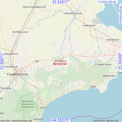
Bilohirsk GPS coordinates[2]
45° 3' 16.632" North, 34° 36' 6.66" East
| Map corner | latitude | longitude |
|---|---|---|
| Upper-left | 45.54917°, | 33.89873° |
| Center: | 45.05462°, | 34.60185° |
| Lower-right: | 44.55575°, | 35.30498° |
| Map W x H: | 110.5×110.5 km | = 68.7×68.7mi |
| max Lat: | 52.18903° ⇑89.4% North |
| Bilohirsk: | 45.05462° |
| min Lat: | ⇓10.6% South 44.39214° |
| min Long | Bilohirsk | max Long |
| 22.20555° | 34.60185° | 40.13222° |
| W 74.6%⇐ | ⇒25.4% E |
Elevation
Elevation of Bilohirsk is 182 m = 597 ft, and this is 26.2 m = 86 ft above average elevation for this country.
| Max E: |
886 m = 2907 ft | 36.2% |
| Bilohirsk | 182 m 597 ft | |
| Avg. | 155.8 m = 511 ft | |
Min E: |
-3 m = -10 ft | 63.8% |
See also: Ukraine elevation on elevation.city.
Geographical zone
Bilohirsk is located in North temperate zone (between Tropic of Cancer and the Arctic Circle). Distance of this North polar circle is 2391.6 km =1486.1 mi to North.| Distance of | km | miles | from Bilohirsk |
|---|---|---|---|
| North Pole | 4997.5 | 3105.3 | to North |
| Arctic Circle | 2391.6 | 1486.1 | to North |
| Tropic Cancer | 2403.7 | 1493.6 | to South |
| Equator | 5009.6 | 3112.8 | to South |


Nearby cities:
15 places around Bilohirsk: (largest is in red/bold)
• Aleksandrovka
6.6 km =4.1 mi,  240°
240°
• Aromatnoye
16 km =9.9 mi,  262°
262°
• Balki
13.4 km =8.3 mi, 239°
• Belaya Skala
4.6 km =2.9 mi,  20°
20°
• Bogatoye
13.3 km =8.3 mi,  102°
102°
• Chernopolye
3.2 km =2 mi,  111°
111°
• Golovanovka
9.1 km =5.7 mi,  165°
165°
• Krinichnoye
3.5 km =2.2 mi, 166°
• Lechebnoye
11.5 km =7.1 mi,  91°
91°
• Michurinskoye
8.5 km =5.3 mi,  75°
75°
• Novoklyonovo
9.9 km =6.2 mi, 237°
• Rusakovka
12.6 km =7.8 mi,  307°
307°
• Vasilyevka
13.4 km =8.3 mi,  45°
45°
• Vishennoye
10.1 km =6.3 mi,  357°
357°
• Zelenogorskoye
11.5 km =7.1 mi,  245°
245°
Sources, notices
• [Note1] Compared only with cities in Ukraine existing in our database
• [Src1] Map data: © OpenStreetMap contributors (CC-BY-SA)
• [Src2] Other city data from geonames.org with taken over terms of usage.
• [Src3] Geographical zone / Annual Mean Temperature by Robert A. Rohde @ Wikipedia
