Trekhprudnoye geodata
Trekhprudnoye (Republic of Crimea) is a populated place; located in Ukraine in Europe/Simferopol (GMT+3) time zone. With population of 925 people, there are 1418 cities with bigger population in this country. Compared to other cities in Ukraine, 93.2% of cities are located further ↑North; 63.3% of cities are located further ←West and 79.6% of cities have lower elevation than Trekhprudnoye. Note1
Administrative division(s):
- Level 1: Republic of Crimea
- Level 2: Simferopol Raion
- Level 3: Chisten'skoye sel'skoye poselenye


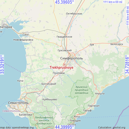
Trekhprudnoye GPS coordinates[2]
44° 54' 0.576" North, 34° 1' 30.108" East
| Map corner | latitude | longitude |
|---|---|---|
| Upper-left | 45.39605°, | 33.32191° |
| Center: | 44.90016°, | 34.02503° |
| Lower-right: | 44.39995°, | 34.72816° |
| Map W x H: | 110.8×110.8 km | = 68.8×68.8mi |
| max Lat: | 52.18903° ⇑93.2% North |
| Trekhprudnoye: | 44.90016° |
| min Lat: | ⇓6.8% South 44.39214° |
| min Long | Trekhprudnoye | max Long |
| 22.20555° | 34.02503° | 40.13222° |
| W 63.3%⇐ | ⇒36.7% E |
Elevation
Elevation of Trekhprudnoye is 244 m = 801 ft, and this is 88.2 m = 289 ft above average elevation for this country.
| Max E: |
886 m = 2907 ft | 20.4% |
| Trekhprudnoye | 244 m 801 ft | |
| Avg. | 155.8 m = 511 ft | |
Min E: |
-3 m = -10 ft | 79.6% |
See also: Ukraine elevation on elevation.city.
Geographical zone
Trekhprudnoye is located in North temperate zone (between Tropic of Cancer and the Arctic Circle). Distance of this Northern Tropic circle is 2386.5 km =1482.9 mi to South.| Distance of | km | miles | from Trekhprudnoye |
|---|---|---|---|
| North Pole | 5014.6 | 3115.9 | to North |
| Arctic Circle | 2408.7 | 1496.7 | to North |
| Tropic Cancer | 2386.5 | 1482.9 | to South |
| Equator | 4992.4 | 3102.1 | to South |


Nearby cities:
15 places around Trekhprudnoye: (largest is in red/bold)
• Chisten’koye
2.7 km =1.7 mi,  139°
139°
• Dubki
4 km =2.5 mi,  358°
358°
• Fontany
3.8 km =2.4 mi,  95°
95°
• Kashtanovoye
8 km =5 mi,  160°
160°
• Kizilovoye
9.2 km =5.7 mi,  170°
170°
• Konstantinovka
9 km =5.6 mi,  123°
123°
• Levadki
3.5 km =2.2 mi, 156°
• Mirnoye
9.7 km =6 mi,  17°
17°
• Partizanskoye
8.7 km =5.4 mi,  147°
147°
• Perovo
3.8 km =2.4 mi,  42°
42°
• Poshtove
8.8 km =5.5 mi,  214°
214°
• Simferopol
9.3 km =5.8 mi,  46°
46°
• Topoli
6.9 km =4.3 mi,  199°
199°
• Ukrainka
9.1 km =5.7 mi, 98°
• Zalesye
6.2 km =3.9 mi, 103°
Sources, notices
• [Note1] Compared only with cities in Ukraine existing in our database
• [Src1] Map data: © OpenStreetMap contributors (CC-BY-SA)
• [Src2] Other city data from geonames.org with taken over terms of usage.
• [Src3] Geographical zone / Annual Mean Temperature by Robert A. Rohde @ Wikipedia
