Levadki geodata
Levadki (Republic of Crimea) is a populated place; located in Ukraine in Europe/Simferopol (GMT+3) time zone. With population of 1,036 people, there are 1358 cities with bigger population in this country. Compared to other cities in Ukraine, 93.9% of cities are located further ↑North; 63.9% of cities are located further ←West and 91.9% of cities have lower elevation than Levadki. Note1
Administrative division(s):
- Level 1: Republic of Crimea
- Level 2: Simferopol Raion
- Level 3: Chisten'skoye sel'skoye poselenye


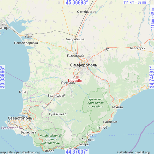
Levadki GPS coordinates[2]
44° 52' 14.988" North, 34° 2' 34.008" East
| Map corner | latitude | longitude |
|---|---|---|
| Upper-left | 45.36698°, | 33.33966° |
| Center: | 44.87083°, | 34.04278° |
| Lower-right: | 44.37037°, | 34.74591° |
| Map W x H: | 110.8×110.8 km | = 68.8×68.8mi |
| max Lat: | 52.18903° ⇑93.9% North |
| Levadki: | 44.87083° |
| min Lat: | ⇓6.1% South 44.39214° |
| min Long | Levadki | max Long |
| 22.20555° | 34.04278° | 40.13222° |
| W 63.9%⇐ | ⇒36.1% E |
Elevation
Elevation of Levadki is 320 m = 1050 ft, and this is 164.2 m = 539 ft above average elevation for this country.
| Max E: |
886 m = 2907 ft | 8.1% |
| Levadki | 320 m 1050 ft | |
| Avg. | 155.8 m = 511 ft | |
Min E: |
-3 m = -10 ft | 91.9% |
See also: Ukraine elevation on elevation.city.
Geographical zone
Levadki is located in North temperate zone (between Tropic of Cancer and the Arctic Circle). Distance of this Northern Tropic circle is 2383.2 km =1480.9 mi to South.| Distance of | km | miles | from Levadki |
|---|---|---|---|
| North Pole | 5017.9 | 3118 | to North |
| Arctic Circle | 2412 | 1498.7 | to North |
| Tropic Cancer | 2383.2 | 1480.9 | to South |
| Equator | 4989.2 | 3100.1 | to South |


Nearby cities:
15 places around Levadki: (largest is in red/bold)
• Chisten’koye
1.2 km =0.7 mi,  16°
16°
• Dubki
7.4 km =4.6 mi,  348°
348°
• Fontany
3.8 km =2.4 mi,  39°
39°
• Kashtanovoye
4.5 km =2.8 mi,  163°
163°
• Kizilovoye
5.8 km =3.6 mi,  179°
179°
• Konstantinovka
6.4 km =4 mi,  105°
105°
• Novopavlovka
8.3 km =5.2 mi,  230°
230°
• Partizanskoye
5.3 km =3.3 mi,  141°
141°
• Perovo
6.1 km =3.8 mi,  10°
10°
• Poshtove
7.5 km =4.7 mi,  238°
238°
• Skalistoye
7.9 km =4.9 mi,  220°
220°
• Topoli
4.9 km =3 mi, 229°
• Trekhprudnoye
3.5 km =2.2 mi,  336°
336°
• Ukrainka
7.9 km =4.9 mi,  76°
76°
• Zalesye
5 km =3.1 mi,  68°
68°
Sources, notices
• [Note1] Compared only with cities in Ukraine existing in our database
• [Src1] Map data: © OpenStreetMap contributors (CC-BY-SA)
• [Src2] Other city data from geonames.org with taken over terms of usage.
• [Src3] Geographical zone / Annual Mean Temperature by Robert A. Rohde @ Wikipedia
