Perovo geodata
Perovo (Republic of Crimea) is a seat of a third-order administrative division; located in Ukraine in Europe/Simferopol (GMT+3) time zone. With population of 3,890 people, there are 773 cities with bigger population in this country. Compared to other cities in Ukraine, 92.9% of cities are located further ↑North; 64.4% of cities are located further ←West and 85.8% of cities have lower elevation than Perovo. Note1
Administrative division(s):
- Level 1: Republic of Crimea
- Level 2: Simferopol Raion
- Level 3: Perovskoye sel'skoye poselenye


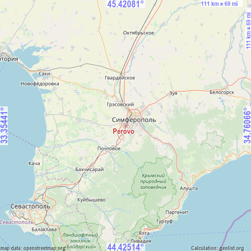
Perovo GPS coordinates[2]
44° 55' 30.468" North, 34° 3' 27.108" East
| Map corner | latitude | longitude |
|---|---|---|
| Upper-left | 45.42081°, | 33.35441° |
| Center: | 44.92513°, | 34.05753° |
| Lower-right: | 44.42514°, | 34.76066° |
| Map W x H: | 110.7×110.7 km | = 68.8×68.8mi |
| max Lat: | 52.18903° ⇑92.9% North |
| Perovo: | 44.92513° |
| min Lat: | ⇓7.1% South 44.39214° |
| min Long | Perovo | max Long |
| 22.20555° | 34.05753° | 40.13222° |
| W 64.4%⇐ | ⇒35.6% E |
Elevation
Elevation of Perovo is 280 m = 919 ft, and this is 124.2 m = 407 ft above average elevation for this country.
| Max E: |
886 m = 2907 ft | 14.2% |
| Perovo | 280 m 919 ft | |
| Avg. | 155.8 m = 511 ft | |
Min E: |
-3 m = -10 ft | 85.8% |
See also: Ukraine elevation on elevation.city.
Geographical zone
Perovo is located in North temperate zone (between Tropic of Cancer and the Arctic Circle). Distance of this Northern Tropic circle is 2389.3 km =1484.6 mi to South.| Distance of | km | miles | from Perovo |
|---|---|---|---|
| North Pole | 5011.9 | 3114.2 | to North |
| Arctic Circle | 2406 | 1495 | to North |
| Tropic Cancer | 2389.3 | 1484.6 | to South |
| Equator | 4995.2 | 3103.9 | to South |


Nearby cities:
15 places around Perovo: (largest is in red/bold)
• Beloglinka
7.9 km =4.9 mi,  350°
350°
• Chisten’koye
4.9 km =3 mi,  189°
189°
• Dubki
2.9 km =1.8 mi,  293°
293°
• Fontany
3.3 km =2.1 mi,  158°
158°
• Gresovskiy
9.5 km =5.9 mi, 345°
• Konstantinovka
9.2 km =5.7 mi,  147°
147°
• Levadki
6.1 km =3.8 mi, 190°
• Lozovoye
8.7 km =5.4 mi,  104°
104°
• Mirnoye
6.5 km =4 mi,  2°
2°
• Molodyozhnoye
8.7 km =5.4 mi,  359°
359°
• Simferopol
5.5 km =3.4 mi,  49°
49°
• Strogonovka
10 km =6.2 mi,  74°
74°
• Trekhprudnoye
3.8 km =2.4 mi,  222°
222°
• Ukrainka
7.7 km =4.8 mi,  123°
123°
• Zalesye
5.5 km =3.4 mi,  140°
140°
Sources, notices
• [Note1] Compared only with cities in Ukraine existing in our database
• [Src1] Map data: © OpenStreetMap contributors (CC-BY-SA)
• [Src2] Other city data from geonames.org with taken over terms of usage.
• [Src3] Geographical zone / Annual Mean Temperature by Robert A. Rohde @ Wikipedia
