Perevalovka geodata
Perevalovka (Republic of Crimea) is a populated place; located in Ukraine in Europe/Simferopol (GMT+3) time zone. With population of 776 people, there are 1502 cities with bigger population in this country. Compared to other cities in Ukraine, 91.8% of cities are located further ↑North; 80.3% of cities are located further ←West and 95.9% of cities have lower elevation than Perevalovka. Note1


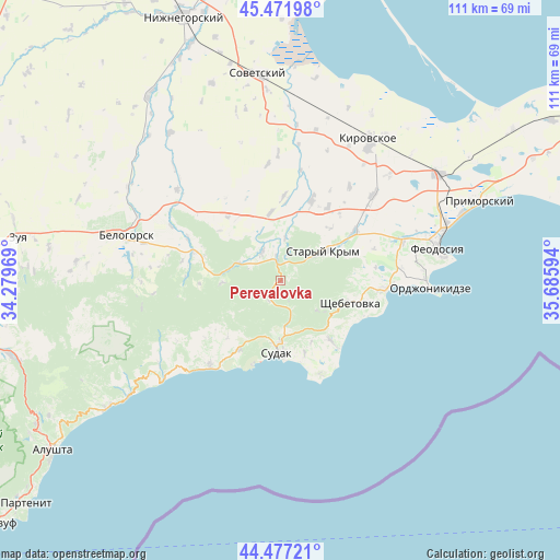
Perevalovka GPS coordinates[2]
44° 58' 36.3" North, 34° 58' 58.116" East
| Map corner | latitude | longitude |
|---|---|---|
| Upper-left | 45.47198°, | 34.27969° |
| Center: | 44.97675°, | 34.98281° |
| Lower-right: | 44.47721°, | 35.68594° |
| Map W x H: | 110.6×110.6 km | = 68.7×68.7mi |
| max Lat: | 52.18903° ⇑91.8% North |
| Perevalovka: | 44.97675° |
| min Lat: | ⇓8.2% South 44.39214° |
| min Long | Perevalovka | max Long |
| 22.20555° | 34.98281° | 40.13222° |
| W 80.3%⇐ | ⇒19.7% E |
Elevation
Elevation of Perevalovka is 380 m = 1247 ft, and this is 224.2 m = 736 ft above average elevation for this country.
| Max E: |
886 m = 2907 ft | 4.1% |
| Perevalovka | 380 m 1247 ft | |
| Avg. | 155.8 m = 511 ft | |
Min E: |
-3 m = -10 ft | 95.9% |
See also: Ukraine elevation on elevation.city.
Geographical zone
Perevalovka is located in North temperate zone (between Tropic of Cancer and the Arctic Circle). Distance of this Northern Tropic circle is 2395 km =1488.2 mi to South.| Distance of | km | miles | from Perevalovka |
|---|---|---|---|
| North Pole | 5006.1 | 3110.6 | to North |
| Arctic Circle | 2400.2 | 1491.4 | to North |
| Tropic Cancer | 2395 | 1488.2 | to South |
| Equator | 5000.9 | 3107.4 | to South |


Nearby cities:
15 places around Perevalovka: (largest is in red/bold)
• Bogatovka
13.4 km =8.3 mi,  153°
153°
• Dachnoye
10.3 km =6.4 mi,  179°
179°
• Grushevka
5.2 km =3.2 mi,  351°
351°
• Izyumovka
14.3 km =8.9 mi,  58°
58°
• Kholodovka
8.5 km =5.3 mi,  5°
5°
• Krasnokamenka
9.3 km =5.8 mi,  128°
128°
• Kurskoye
6.9 km =4.3 mi,  327°
327°
• Lesnoye
4.6 km =2.9 mi,  210°
210°
• L’govskoye
13.6 km =8.5 mi, 351°
• Mezhdurech'e
15.4 km =9.6 mi,  223°
223°
• Shchebetovka
14.4 km =8.9 mi,  107°
107°
• Solnechnaya Dolina
15.2 km =9.4 mi,  140°
140°
• Stary Krym
10.3 km =6.4 mi, 55°
• Sudak
14.2 km =8.8 mi, 182°
• Zemlyanichnoye
11.6 km =7.2 mi,  268°
268°
Sources, notices
• [Note1] Compared only with cities in Ukraine existing in our database
• [Src1] Map data: © OpenStreetMap contributors (CC-BY-SA)
• [Src2] Other city data from geonames.org with taken over terms of usage.
• [Src3] Geographical zone / Annual Mean Temperature by Robert A. Rohde @ Wikipedia
