Grushevka geodata
Grushevka (Republic of Crimea) is a populated place; located in Ukraine in Europe/Simferopol (GMT+3) time zone. With population of 2,269 people, there are 1063 cities with bigger population in this country. Compared to other cities in Ukraine, 90.8% of cities are located further ↑North; 80% of cities are located further ←West and 79.2% of cities have lower elevation than Grushevka. Note1


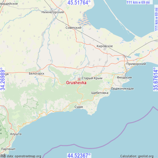
Grushevka GPS coordinates[2]
45° 1' 22.116" North, 34° 58' 22.836" East
| Map corner | latitude | longitude |
|---|---|---|
| Upper-left | 45.51764°, | 34.26989° |
| Center: | 45.02281°, | 34.97301° |
| Lower-right: | 44.52367°, | 35.67614° |
| Map W x H: | 110.5×110.5 km | = 68.7×68.7mi |
| max Lat: | 52.18903° ⇑90.8% North |
| Grushevka: | 45.02281° |
| min Lat: | ⇓9.2% South 44.39214° |
| min Long | Grushevka | max Long |
| 22.20555° | 34.97301° | 40.13222° |
| W 80%⇐ | ⇒20% E |
Elevation
Elevation of Grushevka is 243 m = 797 ft, and this is 87.2 m = 286 ft above average elevation for this country.
| Max E: |
886 m = 2907 ft | 20.8% |
| Grushevka | 243 m 797 ft | |
| Avg. | 155.8 m = 511 ft | |
Min E: |
-3 m = -10 ft | 79.2% |
See also: Ukraine elevation on elevation.city.
Geographical zone
Grushevka is located in North temperate zone (between Tropic of Cancer and the Arctic Circle). Distance of this North polar circle is 2395.1 km =1488.2 mi to North.| Distance of | km | miles | from Grushevka |
|---|---|---|---|
| North Pole | 5001 | 3107.5 | to North |
| Arctic Circle | 2395.1 | 1488.2 | to North |
| Tropic Cancer | 2400.1 | 1491.4 | to South |
| Equator | 5006.1 | 3110.6 | to South |


Nearby cities:
15 places around Grushevka: (largest is in red/bold)
• Abrikosovka
13.8 km =8.6 mi,  46°
46°
• Babenkovo
14.8 km =9.2 mi,  56°
56°
• Dachnoye
15.4 km =9.6 mi,  176°
176°
• Izyumovka
13.1 km =8.1 mi,  79°
79°
• Kholodovka
3.7 km =2.3 mi,  25°
25°
• Krasnokamenka
13.6 km =8.5 mi,  143°
143°
• Kurskoye
3 km =1.9 mi,  283°
283°
• Lesnoye
9.2 km =5.7 mi,  189°
189°
• L’govskoye
8.4 km =5.2 mi,  351°
351°
• Muromskoye
12.3 km =7.6 mi,  307°
307°
• Perevalovka
5.2 km =3.2 mi,  171°
171°
• Privetnoye
12.7 km =7.9 mi, 32°
• Stary Krym
9.4 km =5.8 mi,  85°
85°
• Zemlyanichnoye
12.1 km =7.5 mi,  243°
243°
• Zolotoye Pole
11.8 km =7.3 mi,  7°
7°
Sources, notices
• [Note1] Compared only with cities in Ukraine existing in our database
• [Src1] Map data: © OpenStreetMap contributors (CC-BY-SA)
• [Src2] Other city data from geonames.org with taken over terms of usage.
• [Src3] Geographical zone / Annual Mean Temperature by Robert A. Rohde @ Wikipedia
