Bogatovka geodata
Bogatovka (Republic of Crimea) is a populated place; located in Ukraine in Europe/Simferopol (GMT+3) time zone. With population of 902 people, there are 1431 cities with bigger population in this country. Compared to other cities in Ukraine, 94% of cities are located further ↑North; 80.9% of cities are located further ←West and 53.7% of cities have lower elevation than Bogatovka. Note1


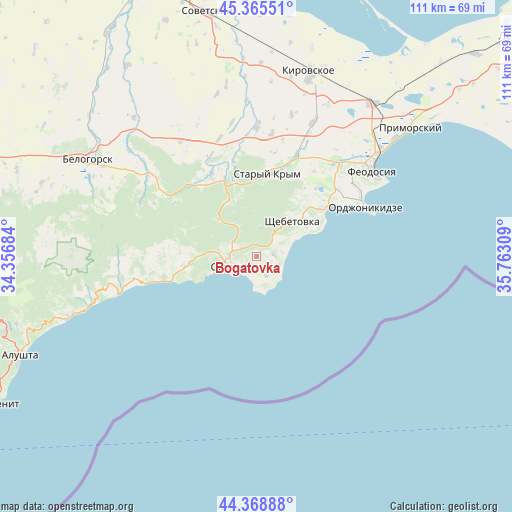
Bogatovka GPS coordinates[2]
44° 52' 9.66" North, 35° 3' 35.856" East
| Map corner | latitude | longitude |
|---|---|---|
| Upper-left | 45.36551°, | 34.35684° |
| Center: | 44.86935°, | 35.05996° |
| Lower-right: | 44.36888°, | 35.76309° |
| Map W x H: | 110.8×110.8 km | = 68.8×68.8mi |
| max Lat: | 52.18903° ⇑94% North |
| Bogatovka: | 44.86935° |
| min Lat: | ⇓6% South 44.39214° |
| min Long | Bogatovka | max Long |
| 22.20555° | 35.05996° | 40.13222° |
| W 80.9%⇐ | ⇒19.1% E |
Elevation
Elevation of Bogatovka is 148 m = 486 ft, and this is 7.8 m = 26 ft below average elevation for this country.
| Max E: |
886 m = 2907 ft | 46.3% |
| Avg. | 155.8 m = 511 ft | |
| Bogatovka | 148 m = 486 ft | |
Min E: |
-3 m = -10 ft | 53.7% |
See also: Ukraine elevation on elevation.city.
Geographical zone
Bogatovka is located in North temperate zone (between Tropic of Cancer and the Arctic Circle). Distance of this Northern Tropic circle is 2383.1 km =1480.8 mi to South.| Distance of | km | miles | from Bogatovka |
|---|---|---|---|
| North Pole | 5018.1 | 3118.1 | to North |
| Arctic Circle | 2412.2 | 1498.9 | to North |
| Tropic Cancer | 2383.1 | 1480.8 | to South |
| Equator | 4989 | 3100 | to South |


Nearby cities:
15 places around Bogatovka: (largest is in red/bold)
• Dachnoye
6.3 km =3.9 mi,  285°
285°
• Grushevka
18.4 km =11.4 mi,  338°
338°
• Izyumovka
20.4 km =12.7 mi,  17°
17°
• Koktebel
17.9 km =11.1 mi,  55°
55°
• Krasnokamenka
6.2 km =3.9 mi,  11°
11°
• Kurskoye
20.3 km =12.6 mi,  331°
331°
• Lesnoye
11.6 km =7.2 mi,  313°
313°
• Mezhdurech'e
16.7 km =10.4 mi,  272°
272°
• Novy Svet
12.3 km =7.6 mi,  249°
249°
• Perevalovka
13.4 km =8.3 mi, 333°
• Shchebetovka
10.9 km =6.8 mi,  45°
45°
• Solnechnaya Dolina
3.7 km =2.3 mi,  85°
85°
• Stary Krym
17.9 km =11.1 mi, 8°
• Sudak
7.1 km =4.4 mi, 251°
• Vesele
14.3 km =8.9 mi,  264°
264°
Sources, notices
• [Note1] Compared only with cities in Ukraine existing in our database
• [Src1] Map data: © OpenStreetMap contributors (CC-BY-SA)
• [Src2] Other city data from geonames.org with taken over terms of usage.
• [Src3] Geographical zone / Annual Mean Temperature by Robert A. Rohde @ Wikipedia
