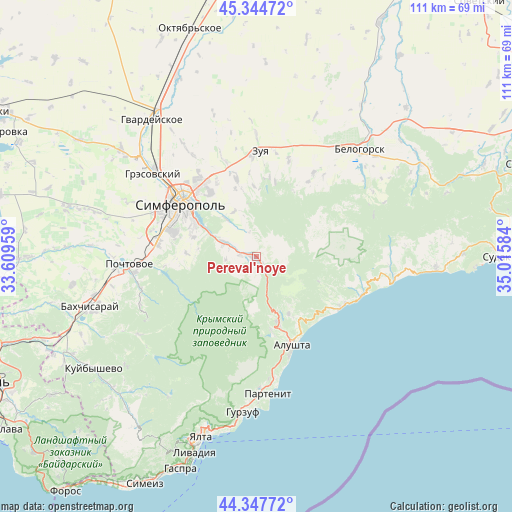
Pereval'noye geodata
Pereval'noye (Republic of Crimea) is a populated place; located in Ukraine in Europe/Simferopol (GMT+3) time zone. With population of 3,426 people, there are 844 cities with bigger population in this country. Compared to other cities in Ukraine, 94.6% of cities are located further ↑North; 69.8% of cities are located further ←West and 96.8% of cities have lower elevation than Pereval'noye. Note1
Administrative division(s):
- Level 1: Republic of Crimea
- Level 2: Simferopol Raion
- Level 3: Dobrovskoye sel'skoye poselenye


Pereval'noye GPS coordinates[2]
44° 50' 54.168" North, 34° 18' 45.756" East
| Map corner | latitude | longitude |
|---|---|---|
| Upper-left | 45.34472°, | 33.60959° |
| Center: | 44.84838°, | 34.31271° |
| Lower-right: | 44.34772°, | 35.01584° |
| Map W x H: | 110.9×110.9 km | = 68.9×68.9mi |
| max Lat: | 52.18903° ⇑94.6% North |
| Pereval'noye: | 44.84838° |
| min Lat: | ⇓5.4% South 44.39214° |
| min Long | Pereval'noye | max Long |
| 22.20555° | 34.31271° | 40.13222° |
| W 69.8%⇐ | ⇒30.2% E |
Elevation
Elevation of Pereval'noye is 418 m = 1371 ft, and this is 262.2 m = 860 ft above average elevation for this country.
| Max E: |
886 m = 2907 ft | 3.2% |
| Pereval'noye | 418 m 1371 ft | |
| Avg. | 155.8 m = 511 ft | |
Min E: |
-3 m = -10 ft | 96.8% |
See also: Ukraine elevation on elevation.city.
Geographical zone
Pereval'noye is located in North temperate zone (between Tropic of Cancer and the Arctic Circle). Distance of this Northern Tropic circle is 2380.8 km =1479.4 mi to South.| Distance of | km | miles | from Pereval'noye |
|---|---|---|---|
| North Pole | 5020.4 | 3119.5 | to North |
| Arctic Circle | 2414.5 | 1500.3 | to North |
| Tropic Cancer | 2380.8 | 1479.4 | to South |
| Equator | 4986.7 | 3098.6 | to South |


Nearby cities:
15 places around Pereval'noye: (largest is in red/bold)
• Andrusovo
11.6 km =7.2 mi,  294°
294°
• Denisovka
10.7 km =6.6 mi,  320°
320°
• Dobroye
7.1 km =4.4 mi, 286°
• Ivanovka
11 km =6.8 mi,  334°
334°
• Konstantinovka
15.2 km =9.4 mi,  272°
272°
• Krasnolesye
6.7 km =4.2 mi,  254°
254°
• Krasnovka
15.4 km =9.6 mi,  342°
342°
• Lozovoye
13.3 km =8.3 mi,  298°
298°
• Luchistoye
14.2 km =8.8 mi,  150°
150°
• Nizhnyaya Kutuzovka
16.4 km =10.2 mi,  161°
161°
• Pionerskoye
9.4 km =5.8 mi, 292°
• Strogonovka
15.4 km =9.6 mi, 316°
• Ukrainka
14.3 km =8.9 mi, 287°
• Verkhnyaya Kutuzovka
14.8 km =9.2 mi, 162°
• Zarechnoye
3.8 km =2.4 mi, 273°
Sources, notices
• [Note1] Compared only with cities in Ukraine existing in our database
• [Src1] Map data: © OpenStreetMap contributors (CC-BY-SA)
• [Src2] Other city data from geonames.org with taken over terms of usage.
• [Src3] Geographical zone / Annual Mean Temperature by Robert A. Rohde @ Wikipedia
