Ivanovka geodata
Ivanovka (Republic of Crimea) is a populated place; located in Ukraine in Europe/Simferopol (GMT+3) time zone. With population of 899 people, there are 1433 cities with bigger population in this country. Compared to other cities in Ukraine, 92.6% of cities are located further ↑North; 68.6% of cities are located further ←West and 96.7% of cities have lower elevation than Ivanovka. Note1
Administrative division(s):
- Level 1: Republic of Crimea
- Level 2: Simferopol Raion
- Level 3: Trudovskoye sel'skoye poselenye


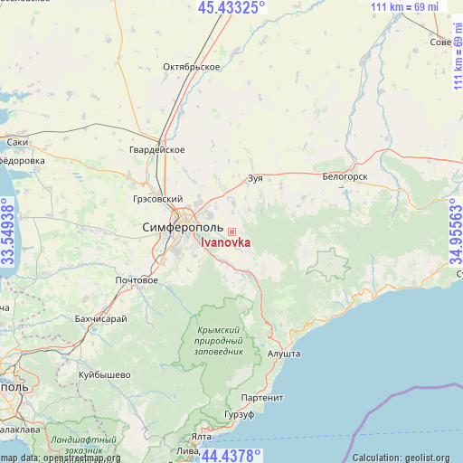
Ivanovka GPS coordinates[2]
44° 56' 15.648" North, 34° 15' 9" East
| Map corner | latitude | longitude |
|---|---|---|
| Upper-left | 45.43325°, | 33.54938° |
| Center: | 44.93768°, | 34.2525° |
| Lower-right: | 44.4378°, | 34.95563° |
| Map W x H: | 110.7×110.7 km | = 68.8×68.8mi |
| max Lat: | 52.18903° ⇑92.6% North |
| Ivanovka: | 44.93768° |
| min Lat: | ⇓7.4% South 44.39214° |
| min Long | Ivanovka | max Long |
| 22.20555° | 34.2525° | 40.13222° |
| W 68.6%⇐ | ⇒31.4% E |
Elevation
Elevation of Ivanovka is 415 m = 1362 ft, and this is 259.2 m = 850 ft above average elevation for this country.
| Max E: |
886 m = 2907 ft | 3.3% |
| Ivanovka | 415 m 1362 ft | |
| Avg. | 155.8 m = 511 ft | |
Min E: |
-3 m = -10 ft | 96.7% |
See also: Ukraine elevation on elevation.city.
Geographical zone
Ivanovka is located in North temperate zone (between Tropic of Cancer and the Arctic Circle). Distance of this Northern Tropic circle is 2390.7 km =1485.5 mi to South.| Distance of | km | miles | from Ivanovka |
|---|---|---|---|
| North Pole | 5010.5 | 3113.4 | to North |
| Arctic Circle | 2404.6 | 1494.1 | to North |
| Tropic Cancer | 2390.7 | 1485.5 | to South |
| Equator | 4996.6 | 3104.7 | to South |


Nearby cities:
15 places around Ivanovka: (largest is in red/bold)
• Andrusovo
7.7 km =4.8 mi,  228°
228°
• Aykavan
10.1 km =6.3 mi,  310°
310°
• Denisovka
2.6 km =1.6 mi, 229°
• Dobroye
8.2 km =5.1 mi,  194°
194°
• Krasnolesye
11.8 km =7.3 mi, 188°
• Krasnovka
4.7 km =2.9 mi,  0°
0°
• Lozovoye
7.8 km =4.8 mi,  243°
243°
• Mazanka
7.5 km =4.7 mi, 1°
• Pereval'noye
11 km =6.8 mi,  154°
154°
• Pionerskoye
7.5 km =4.7 mi,  212°
212°
• Simferopol
11.4 km =7.1 mi,  281°
281°
• Strogonovka
5.9 km =3.7 mi, 283°
• Trudovoye
7.1 km =4.4 mi,  326°
326°
• Ukrainka
10.5 km =6.5 mi, 237°
• Zarechnoye
9.7 km =6 mi,  174°
174°
Sources, notices
• [Note1] Compared only with cities in Ukraine existing in our database
• [Src1] Map data: © OpenStreetMap contributors (CC-BY-SA)
• [Src2] Other city data from geonames.org with taken over terms of usage.
• [Src3] Geographical zone / Annual Mean Temperature by Robert A. Rohde @ Wikipedia
