Denisovka geodata
Denisovka (Republic of Crimea) is a populated place; located in Ukraine in Europe/Simferopol (GMT+3) time zone. With population of 972 people, there are 1397 cities with bigger population in this country. Compared to other cities in Ukraine, 93% of cities are located further ↑North; 68.1% of cities are located further ←West and 95.1% of cities have lower elevation than Denisovka. Note1
Administrative division(s):
- Level 1: Republic of Crimea
- Level 2: Simferopol Raion
- Level 3: Trudovskoye sel'skoye poselenye


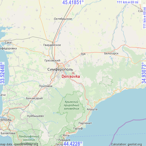
Denisovka GPS coordinates[2]
44° 55' 22.116" North, 34° 13' 39.36" East
| Map corner | latitude | longitude |
|---|---|---|
| Upper-left | 45.41851°, | 33.52448° |
| Center: | 44.92281°, | 34.2276° |
| Lower-right: | 44.4228°, | 34.93073° |
| Map W x H: | 110.7×110.7 km | = 68.8×68.8mi |
| max Lat: | 52.18903° ⇑93% North |
| Denisovka: | 44.92281° |
| min Lat: | ⇓7% South 44.39214° |
| min Long | Denisovka | max Long |
| 22.20555° | 34.2276° | 40.13222° |
| W 68.1%⇐ | ⇒31.9% E |
Elevation
Elevation of Denisovka is 364 m = 1194 ft, and this is 208.2 m = 683 ft above average elevation for this country.
| Max E: |
886 m = 2907 ft | 4.9% |
| Denisovka | 364 m 1194 ft | |
| Avg. | 155.8 m = 511 ft | |
Min E: |
-3 m = -10 ft | 95.1% |
See also: Ukraine elevation on elevation.city.
Geographical zone
Denisovka is located in North temperate zone (between Tropic of Cancer and the Arctic Circle). Distance of this Northern Tropic circle is 2389 km =1484.5 mi to South.| Distance of | km | miles | from Denisovka |
|---|---|---|---|
| North Pole | 5012.1 | 3114.4 | to North |
| Arctic Circle | 2406.2 | 1495.1 | to North |
| Tropic Cancer | 2389 | 1484.5 | to South |
| Equator | 4994.9 | 3103.7 | to South |


Nearby cities:
15 places around Denisovka: (largest is in red/bold)
• Andrusovo
5.2 km =3.2 mi,  227°
227°
• Aykavan
10 km =6.2 mi,  325°
325°
• Dobroye
6.3 km =3.9 mi,  180°
180°
• Ivanovka
2.6 km =1.6 mi,  49°
49°
• Krasnolesye
10 km =6.2 mi, 178°
• Krasnovka
6.7 km =4.2 mi,  17°
17°
• Lozovoye
5.3 km =3.3 mi,  249°
249°
• Mazanka
9.5 km =5.9 mi,  13°
13°
• Pereval'noye
10.7 km =6.6 mi,  140°
140°
• Pionerskoye
5.1 km =3.2 mi,  203°
203°
• Simferopol
10 km =6.2 mi,  292°
292°
• Strogonovka
4.8 km =3 mi,  308°
308°
• Trudovoye
7.9 km =4.9 mi,  345°
345°
• Ukrainka
8 km =5 mi,  240°
240°
• Zarechnoye
8.5 km =5.3 mi,  160°
160°
Sources, notices
• [Note1] Compared only with cities in Ukraine existing in our database
• [Src1] Map data: © OpenStreetMap contributors (CC-BY-SA)
• [Src2] Other city data from geonames.org with taken over terms of usage.
• [Src3] Geographical zone / Annual Mean Temperature by Robert A. Rohde @ Wikipedia
