Nizhnyaya Kutuzovka geodata
Nizhnyaya Kutuzovka (Republic of Crimea) is a populated place; located in Ukraine in Europe/Simferopol (GMT+3) time zone. With population of 976 people, there are 1394 cities with bigger population in this country. Compared to other cities in Ukraine, 97% of cities are located further ↑North; 71.5% of cities are located further ←West and 61% of cities have lower elevation than Nizhnyaya Kutuzovka. Note1


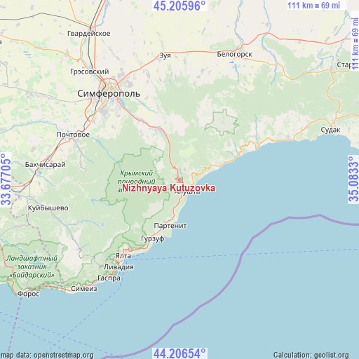
Nizhnyaya Kutuzovka GPS coordinates[2]
44° 42' 30.276" North, 34° 22' 48.612" East
| Map corner | latitude | longitude |
|---|---|---|
| Upper-left | 45.20596°, | 33.67705° |
| Center: | 44.70841°, | 34.38017° |
| Lower-right: | 44.20654°, | 35.0833° |
| Map W x H: | 111.1×111.1 km | = 69×69mi |
| max Lat: | 52.18903° ⇑97% North |
| Nizhnyaya Kutuzovka: | 44.70841° |
| min Lat: | ⇓3% South 44.39214° |
| min Long | Nizhnyaya Kutuz | max Long |
| 22.20555° | 34.38017° | 40.13222° |
| W 71.5%⇐ | ⇒28.5% E |
Elevation
Elevation of Nizhnyaya Kutuzovka is 172 m = 564 ft, and this is 16.2 m = 53 ft above average elevation for this country.
| Max E: |
886 m = 2907 ft | 39% |
| Nizhnyaya Kutuzovka | 172 m 564 ft | |
| Avg. | 155.8 m = 511 ft | |
Min E: |
-3 m = -10 ft | 61% |
See also: Ukraine elevation on elevation.city.
Geographical zone
Nizhnyaya Kutuzovka is located in North temperate zone (between Tropic of Cancer and the Arctic Circle). Distance of this Northern Tropic circle is 2365.2 km =1469.7 mi to South.| Distance of | km | miles | from Nizhnyaya Kutuzovka |
|---|---|---|---|
| North Pole | 5036 | 3129.2 | to North |
| Arctic Circle | 2430.1 | 1510 | to North |
| Tropic Cancer | 2365.2 | 1469.7 | to South |
| Equator | 4971.1 | 3088.9 | to South |


Nearby cities:
15 places around Nizhnyaya Kutuzovka: (largest is in red/bold)
• Alushta
4.2 km =2.6 mi,  146°
146°
• Gurzuf
19.7 km =12.2 mi,  204°
204°
• Izobil’noye
2.2 km =1.4 mi,  253°
253°
• Krasnokamenka
17.6 km =10.9 mi, 204°
• Krasnolesye
18.2 km =11.3 mi,  319°
319°
• Luchistoye
3.5 km =2.2 mi,  27°
27°
• Malorechenskoye
15.1 km =9.4 mi,  68°
68°
• Maly Mayak
10.6 km =6.6 mi,  186°
186°
• Partenit
14.8 km =9.2 mi, 190°
• Pereval'noye
16.4 km =10.2 mi,  341°
341°
• Rybach'e
18.5 km =11.5 mi, 67°
• Solnechnogorskoye
13.3 km =8.3 mi, 71°
• Verkhnyaya Kutuzovka
1.7 km =1.1 mi,  330°
330°
• Zaprudnoye
13.8 km =8.6 mi, 200°
• Zarechnoye
18.3 km =11.4 mi, 329°
Sources, notices
• [Note1] Compared only with cities in Ukraine existing in our database
• [Src1] Map data: © OpenStreetMap contributors (CC-BY-SA)
• [Src2] Other city data from geonames.org with taken over terms of usage.
• [Src3] Geographical zone / Annual Mean Temperature by Robert A. Rohde @ Wikipedia
