Nova Vodolaha geodata
Nova Vodolaha (Kharkiv) is a seat of a second-order administrative division; located in Ukraine in Europe/Kiev (GMT+3) time zone. With population of 13,112 people, there are 283 cities with bigger population in this country. Compared to other cities in Ukraine, 78.4% of cities are located further ↓South; 86.3% of cities are located further ←West and 56.5% of cities have higher elevation than Nova Vodolaha. Note1


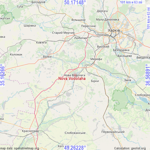
Nova Vodolaha GPS coordinates[2]
49° 43' 8.436" North, 35° 51' 56.808" East
| Map corner | latitude | longitude |
|---|---|---|
| Upper-left | 50.17148°, | 35.16266° |
| Center: | 49.71901°, | 35.86578° |
| Lower-right: | 49.26228°, | 36.56891° |
| Map W x H: | 101.1×101.1 km | = 62.8×62.8mi |
| max Lat: | 52.18903° ⇑21.6% North |
| Nova Vodolaha: | 49.71901° |
| min Lat: | ⇓78.4% South 44.39214° |
| min Long | Nova Vodolaha | max Long |
| 22.20555° | 35.86578° | 40.13222° |
| W 86.3%⇐ | ⇒13.7% E |
Elevation
Elevation of Nova Vodolaha is 116 m = 381 ft, and this is 39.8 m = 131 ft below average elevation for this country.
| Max E: |
886 m = 2907 ft | 56.5% |
| Avg. | 155.8 m = 511 ft | |
| Nova Vodolaha | 116 m = 381 ft | |
Min E: |
-3 m = -10 ft | 43.5% |
See also: Ukraine elevation on elevation.city.
Geographical zone
Nova Vodolaha is located in North temperate zone (between Tropic of Cancer and the Arctic Circle). Distance of this North polar circle is 1872.9 km =1163.8 mi to North.| Distance of | km | miles | from Nova Vodolaha |
|---|---|---|---|
| North Pole | 4478.8 | 2783 | to North |
| Arctic Circle | 1872.9 | 1163.8 | to North |
| Tropic Cancer | 2922.3 | 1815.8 | to South |
| Equator | 5528.2 | 3435.1 | to South |


Nearby cities:
15 places around Nova Vodolaha: (largest is in red/bold)
• Berezivka
33.1 km =20.6 mi,  200°
200°
• Budy
22.2 km =13.8 mi,  30°
30°
• Khorosheve
29.4 km =18.3 mi,  59°
59°
• Korotych
28.2 km =17.5 mi, 25°
• Lyubotyn
25.7 km =16 mi,  10°
10°
• Manchenky
29 km =18 mi,  358°
358°
• Merefa
17.6 km =10.9 mi,  48°
48°
• Pivdenne
23.3 km =14.5 mi,  38°
38°
• Pokotylivka
31 km =19.3 mi, 45°
• Shlyakh
24 km =14.9 mi,  342°
342°
• Solonytsivka
33.2 km =20.6 mi,  21°
21°
• Staryy Merchyk
30.2 km =18.8 mi,  345°
345°
• Utkivka
16.8 km =10.4 mi, 63°
• Valky
22.4 km =13.9 mi,  305°
305°
• Vysokyy
26.6 km =16.5 mi, 43°
Sources, notices
• [Note1] Compared only with cities in Ukraine existing in our database
• [Src1] Map data: © OpenStreetMap contributors (CC-BY-SA)
• [Src2] Other city data from geonames.org with taken over terms of usage.
• [Src3] Geographical zone / Annual Mean Temperature by Robert A. Rohde @ Wikipedia
