Khorosheve geodata
Khorosheve (Kharkiv) is a populated place; located in Ukraine in Europe/Kiev (GMT+3) time zone. With population of 4,432 people, there are 707 cities with bigger population in this country. Compared to other cities in Ukraine, 81% of cities are located further ↓South; 88.3% of cities are located further ←West and 52.2% of cities have higher elevation than Khorosheve. Note1


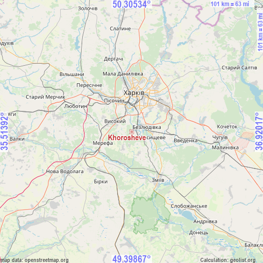
Khorosheve GPS coordinates[2]
49° 51' 14.868" North, 36° 13' 1.344" East
| Map corner | latitude | longitude |
|---|---|---|
| Upper-left | 50.30534°, | 35.51392° |
| Center: | 49.85413°, | 36.21704° |
| Lower-right: | 49.39867°, | 36.92017° |
| Map W x H: | 100.8×100.8 km | = 62.6×62.6mi |
| max Lat: | 52.18903° ⇑19% North |
| Khorosheve: | 49.85413° |
| min Lat: | ⇓81% South 44.39214° |
| min Long | Khorosheve | max Long |
| 22.20555° | 36.21704° | 40.13222° |
| W 88.3%⇐ | ⇒11.7% E |
Elevation
Elevation of Khorosheve is 127 m = 417 ft, and this is 28.8 m = 94 ft below average elevation for this country.
| Max E: |
886 m = 2907 ft | 52.2% |
| Avg. | 155.8 m = 511 ft | |
| Khorosheve | 127 m = 417 ft | |
Min E: |
-3 m = -10 ft | 47.8% |
See also: Ukraine elevation on elevation.city.
Geographical zone
Khorosheve is located in North temperate zone (between Tropic of Cancer and the Arctic Circle). Distance of this North polar circle is 1857.9 km =1154.4 mi to North.| Distance of | km | miles | from Khorosheve |
|---|---|---|---|
| North Pole | 4463.8 | 2773.7 | to North |
| Arctic Circle | 1857.9 | 1154.4 | to North |
| Tropic Cancer | 2937.3 | 1825.2 | to South |
| Equator | 5543.3 | 3444.4 | to South |


Nearby cities:
15 places around Khorosheve: (largest is in red/bold)
• Bezlyudivka
4.2 km =2.6 mi,  55°
55°
• Budy
14.6 km =9.1 mi,  286°
286°
• Kharkiv
14.3 km =8.9 mi,  10°
10°
• Korotych
16.5 km =10.3 mi,  308°
308°
• Kulynychi
18.5 km =11.5 mi,  39°
39°
• Lyubotyn
23.1 km =14.4 mi,  296°
296°
• Merefa
12.4 km =7.7 mi,  253°
253°
• Pivdenne
11.2 km =7 mi, 286°
• Pokotylivka
7.2 km =4.5 mi,  335°
335°
• Solonytsivka
20.5 km =12.7 mi,  320°
320°
• Utkivka
12.7 km =7.9 mi,  233°
233°
• Vasyshcheve
8.4 km =5.2 mi,  109°
109°
• Vvedenka
20.8 km =12.9 mi,  99°
99°
• Vysokyy
8 km =5 mi, 301°
• Zmiyiv
22.1 km =13.7 mi,  154°
154°
Sources, notices
• [Note1] Compared only with cities in Ukraine existing in our database
• [Src1] Map data: © OpenStreetMap contributors (CC-BY-SA)
• [Src2] Other city data from geonames.org with taken over terms of usage.
• [Src3] Geographical zone / Annual Mean Temperature by Robert A. Rohde @ Wikipedia
