Novoestoniya geodata
Novoestoniya (Republic of Crimea) is a populated place; located in Ukraine in Europe/Simferopol (GMT+3) time zone. With population of 1,027 people, there are 1363 cities with bigger population in this country. Compared to other cities in Ukraine, 77.2% of cities are located further ↑North; 68.5% of cities are located further ←West and 77.9% of cities have higher elevation than Novoestoniya. Note1
Administrative division(s):
- Level 1: Republic of Crimea
- Level 2: Krasnohvardiiske Raion
- Level 3: Petrovskoye sel'skoye poselenye


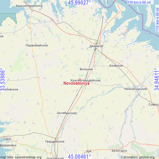
Novoestoniya GPS coordinates[2]
45° 29' 58.56" North, 34° 14' 34.728" East
| Map corner | latitude | longitude |
|---|---|---|
| Upper-left | 45.99027°, | 33.53986° |
| Center: | 45.4996°, | 34.24298° |
| Lower-right: | 45.00461°, | 34.94611° |
| Map W x H: | 109.6×109.6 km | = 68.1×68.1mi |
| max Lat: | 52.18903° ⇑77.2% North |
| Novoestoniya: | 45.4996° |
| min Lat: | ⇓22.8% South 44.39214° |
| min Long | Novoestoniya | max Long |
| 22.20555° | 34.24298° | 40.13222° |
| W 68.5%⇐ | ⇒31.5% E |
Elevation
Elevation of Novoestoniya is 51 m = 167 ft, and this is 104.8 m = 344 ft below average elevation for this country.
| Max E: |
886 m = 2907 ft | 77.9% |
| Avg. | 155.8 m = 511 ft | |
| Novoestoniya | 51 m = 167 ft | |
Min E: |
-3 m = -10 ft | 22.1% |
See also: Ukraine elevation on elevation.city.
Geographical zone
Novoestoniya is located in North temperate zone (between Tropic of Cancer and the Arctic Circle). Distance of this North polar circle is 2342.1 km =1455.3 mi to North.| Distance of | km | miles | from Novoestoniya |
|---|---|---|---|
| North Pole | 4948 | 3074.5 | to North |
| Arctic Circle | 2342.1 | 1455.3 | to North |
| Tropic Cancer | 2453.2 | 1524.3 | to South |
| Equator | 5059.1 | 3143.6 | to South |


Nearby cities:
15 places around Novoestoniya: (largest is in red/bold)
• Blizhneye
5.1 km =3.2 mi,  59°
59°
• Klepinino
5.6 km =3.5 mi,  304°
304°
• Kommunary
5.6 km =3.5 mi,  343°
343°
• Krasnaya Polyana
9.4 km =5.8 mi,  252°
252°
• Krasnogvardeyskoye
4.6 km =2.9 mi,  85°
85°
• Krasny Partizan
10.8 km =6.7 mi,  188°
188°
• Mar’yanovka
7.2 km =4.5 mi,  145°
145°
• Mirolyubovka
3.6 km =2.2 mi,  206°
206°
• Nekrasovo
9 km =5.6 mi,  158°
158°
• Petrovka
3.5 km =2.2 mi, 93°
• Pushkino
6.4 km =4 mi,  50°
50°
• Shcherbakovo
8.5 km =5.3 mi,  102°
102°
• Vidnoye
7.4 km =4.6 mi, 87°
• Vol’noye
8.7 km =5.4 mi,  32°
32°
• Yantarnoye
7.4 km =4.6 mi, 193°
Sources, notices
• [Note1] Compared only with cities in Ukraine existing in our database
• [Src1] Map data: © OpenStreetMap contributors (CC-BY-SA)
• [Src2] Other city data from geonames.org with taken over terms of usage.
• [Src3] Geographical zone / Annual Mean Temperature by Robert A. Rohde @ Wikipedia
