Yantarnoye geodata
Yantarnoye (Republic of Crimea) is a seat of a third-order administrative division; located in Ukraine in Europe/Simferopol (GMT+3) time zone. With population of 2,368 people, there are 1051 cities with bigger population in this country. Compared to other cities in Ukraine, 79% of cities are located further ↑North; 67.9% of cities are located further ←West and 77.2% of cities have higher elevation than Yantarnoye. Note1
Administrative division(s):
- Level 1: Republic of Crimea
- Level 2: Krasnohvardiiske Raion
- Level 3: Yantarnenskoye sel'skoye poselenye


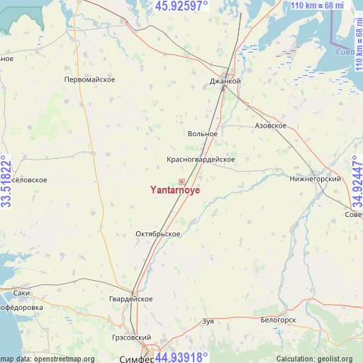
Yantarnoye GPS coordinates[2]
45° 26' 5.028" North, 34° 13' 16.824" East
| Map corner | latitude | longitude |
|---|---|---|
| Upper-left | 45.92597°, | 33.51822° |
| Center: | 45.43473°, | 34.22134° |
| Lower-right: | 44.93918°, | 34.92447° |
| Map W x H: | 109.7×109.7 km | = 68.2×68.2mi |
| max Lat: | 52.18903° ⇑79% North |
| Yantarnoye: | 45.43473° |
| min Lat: | ⇓21% South 44.39214° |
| min Long | Yantarnoye | max Long |
| 22.20555° | 34.22134° | 40.13222° |
| W 67.9%⇐ | ⇒32.1% E |
Elevation
Elevation of Yantarnoye is 53 m = 174 ft, and this is 102.8 m = 337 ft below average elevation for this country.
| Max E: |
886 m = 2907 ft | 77.2% |
| Avg. | 155.8 m = 511 ft | |
| Yantarnoye | 53 m = 174 ft | |
Min E: |
-3 m = -10 ft | 22.8% |
See also: Ukraine elevation on elevation.city.
Geographical zone
Yantarnoye is located in North temperate zone (between Tropic of Cancer and the Arctic Circle). Distance of this North polar circle is 2349.3 km =1459.8 mi to North.| Distance of | km | miles | from Yantarnoye |
|---|---|---|---|
| North Pole | 4955.2 | 3079 | to North |
| Arctic Circle | 2349.3 | 1459.8 | to North |
| Tropic Cancer | 2445.9 | 1519.8 | to South |
| Equator | 5051.9 | 3139.1 | to South |


Nearby cities:
15 places around Yantarnoye: (largest is in red/bold)
• Dubrovskoye
9 km =5.6 mi,  237°
237°
• Klepinino
10.8 km =6.7 mi,  343°
343°
• Komarovka
9.8 km =6.1 mi,  210°
210°
• Krasnaya Polyana
8.4 km =5.2 mi,  300°
300°
• Krasnogvardeyskoye
9.8 km =6.1 mi,  39°
39°
• Krasny Partizan
3.4 km =2.1 mi,  178°
178°
• Kremnevka
11.2 km =7 mi,  289°
289°
• Mar’yanovka
5.9 km =3.7 mi,  77°
77°
• Mirolyubovka
4 km =2.5 mi,  1°
1°
• Nekrasovo
5.1 km =3.2 mi,  102°
102°
• Novoestoniya
7.4 km =4.6 mi,  13°
13°
• Petrovka
8.7 km =5.4 mi, 36°
• Poltavka
9.7 km =6 mi,  197°
197°
• Shcherbakovo
11.4 km =7.1 mi,  61°
61°
• Udachnoye
7 km =4.3 mi,  137°
137°
Sources, notices
• [Note1] Compared only with cities in Ukraine existing in our database
• [Src1] Map data: © OpenStreetMap contributors (CC-BY-SA)
• [Src2] Other city data from geonames.org with taken over terms of usage.
• [Src3] Geographical zone / Annual Mean Temperature by Robert A. Rohde @ Wikipedia
