Kommunary geodata
Kommunary (Republic of Crimea) is a populated place; located in Ukraine in Europe/Simferopol (GMT+3) time zone. With population of 598 people, there are 1585 cities with bigger population in this country. Compared to other cities in Ukraine, 76% of cities are located further ↑North; 68% of cities are located further ←West and 80.6% of cities have higher elevation than Kommunary. Note1
Administrative division(s):
- Level 1: Republic of Crimea
- Level 2: Krasnohvardiiske Raion
- Level 3: Kalininskoye sel'skoye poselenye


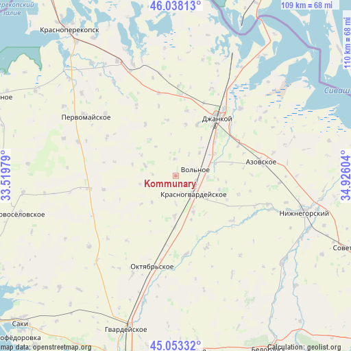
Kommunary GPS coordinates[2]
45° 32' 52.368" North, 34° 13' 22.476" East
| Map corner | latitude | longitude |
|---|---|---|
| Upper-left | 46.03813°, | 33.51979° |
| Center: | 45.54788°, | 34.22291° |
| Lower-right: | 45.05332°, | 34.92604° |
| Map W x H: | 109.5×109.5 km | = 68×68mi |
| max Lat: | 52.18903° ⇑76% North |
| Kommunary: | 45.54788° |
| min Lat: | ⇓24% South 44.39214° |
| min Long | Kommunary | max Long |
| 22.20555° | 34.22291° | 40.13222° |
| W 68%⇐ | ⇒32% E |
Elevation
Elevation of Kommunary is 41 m = 135 ft, and this is 114.8 m = 377 ft below average elevation for this country.
| Max E: |
886 m = 2907 ft | 80.6% |
| Avg. | 155.8 m = 511 ft | |
| Kommunary | 41 m = 135 ft | |
Min E: |
-3 m = -10 ft | 19.4% |
See also: Ukraine elevation on elevation.city.
Geographical zone
Kommunary is located in North temperate zone (between Tropic of Cancer and the Arctic Circle). Distance of this North polar circle is 2336.7 km =1452 mi to North.| Distance of | km | miles | from Kommunary |
|---|---|---|---|
| North Pole | 4942.6 | 3071.2 | to North |
| Arctic Circle | 2336.7 | 1452 | to North |
| Tropic Cancer | 2458.5 | 1527.6 | to South |
| Equator | 5064.4 | 3146.9 | to South |


Nearby cities:
15 places around Kommunary: (largest is in red/bold)
• Aleksandrovka
10.1 km =6.3 mi,  288°
288°
• Blizhneye
6.6 km =4.1 mi,  115°
115°
• Kalinino
5.3 km =3.3 mi,  357°
357°
• Karpovka
11.4 km =7.1 mi,  256°
256°
• Klepinino
3.8 km =2.4 mi,  234°
234°
• Krasnaya Polyana
11 km =6.8 mi,  221°
221°
• Krasnogvardeyskoye
7.9 km =4.9 mi,  129°
129°
• Mirolyubovka
8.6 km =5.3 mi,  180°
180°
• Novoestoniya
5.6 km =3.5 mi,  163°
163°
• Petrovka
7.5 km =4.7 mi,  137°
137°
• Pushkino
6.6 km =4.1 mi,  101°
101°
• Vidnoye
10.3 km =6.4 mi, 119°
• Vol’noye
6.6 km =4.1 mi,  72°
72°
• Yarkoye Pole
10.4 km =6.5 mi,  45°
45°
• Zernovoye
11 km =6.8 mi,  325°
325°
Sources, notices
• [Note1] Compared only with cities in Ukraine existing in our database
• [Src1] Map data: © OpenStreetMap contributors (CC-BY-SA)
• [Src2] Other city data from geonames.org with taken over terms of usage.
• [Src3] Geographical zone / Annual Mean Temperature by Robert A. Rohde @ Wikipedia
