Nauchny geodata
Nauchny (Republic of Crimea) is a populated place; located in Ukraine in Europe/Simferopol (GMT+3) time zone. With population of 723 people, there are 1523 cities with bigger population in this country. Compared to other cities in Ukraine, 96.8% of cities are located further ↑North; 63% of cities are located further ←West and 99% of cities have lower elevation than Nauchny. Note1
Administrative division(s):
- Level 1: Republic of Crimea
- Level 2: Bakhchysarai Raion
- Level 3: Gorodskoye poselenye Bakhchisaray


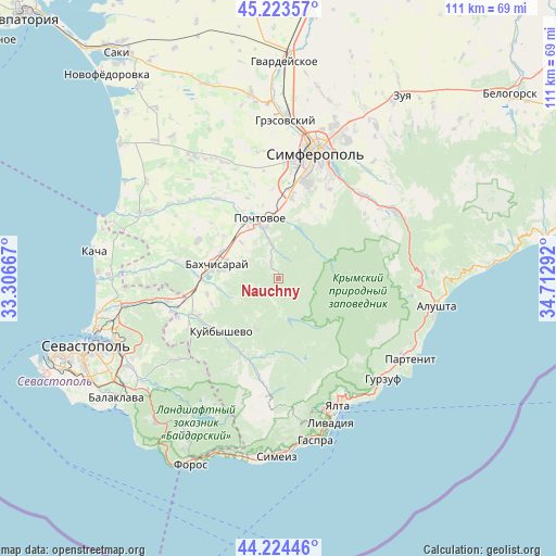
Nauchny GPS coordinates[2]
44° 43' 34.212" North, 34° 0' 35.244" East
| Map corner | latitude | longitude |
|---|---|---|
| Upper-left | 45.22357°, | 33.30667° |
| Center: | 44.72617°, | 34.00979° |
| Lower-right: | 44.22446°, | 34.71292° |
| Map W x H: | 111.1×111.1 km | = 69×69mi |
| max Lat: | 52.18903° ⇑96.8% North |
| Nauchny: | 44.72617° |
| min Lat: | ⇓3.2% South 44.39214° |
| min Long | Nauchny | max Long |
| 22.20555° | 34.00979° | 40.13222° |
| W 63%⇐ | ⇒37% E |
Elevation
Elevation of Nauchny is 582 m = 1909 ft, and this is 426.2 m = 1398 ft above average elevation for this country.
| Max E: |
886 m = 2907 ft | 1% |
| Nauchny | 582 m 1909 ft | |
| Avg. | 155.8 m = 511 ft | |
Min E: |
-3 m = -10 ft | 99% |
See also: Ukraine elevation on elevation.city.
Geographical zone
Nauchny is located in North temperate zone (between Tropic of Cancer and the Arctic Circle). Distance of this Northern Tropic circle is 2367.2 km =1470.9 mi to South.| Distance of | km | miles | from Nauchny |
|---|---|---|---|
| North Pole | 5034 | 3128 | to North |
| Arctic Circle | 2428.1 | 1508.8 | to North |
| Tropic Cancer | 2367.2 | 1470.9 | to South |
| Equator | 4973.1 | 3090.1 | to South |


Nearby cities:
15 places around Nauchny: (largest is in red/bold)
• Bakhchysarai
12.4 km =7.7 mi,  285°
285°
• Glubokiy Yar
10.4 km =6.5 mi,  314°
314°
• Kashtanovoye
12.4 km =7.7 mi,  18°
18°
• Kizilovoye
10.7 km =6.6 mi,  14°
14°
• Novopavlovka
11.4 km =7.1 mi,  340°
340°
• Partizanskoye
13.3 km =8.3 mi,  26°
26°
• Poshtove
12.7 km =7.9 mi, 342°
• Predushchel’noye
11.2 km =7 mi,  258°
258°
• Prokhladnoye
3.7 km =2.3 mi, 337°
• Samokhvalovo
13 km =8.1 mi,  327°
327°
• Sevastyanovka
12 km =7.5 mi, 329°
• Skalistoye
10.4 km =6.5 mi,  345°
345°
• Topoli
12.9 km =8 mi,  355°
355°
• Trudolyubovka
6.9 km =4.3 mi, 349°
• Verkhorechye
3.7 km =2.3 mi,  209°
209°
Sources, notices
• [Note1] Compared only with cities in Ukraine existing in our database
• [Src1] Map data: © OpenStreetMap contributors (CC-BY-SA)
• [Src2] Other city data from geonames.org with taken over terms of usage.
• [Src3] Geographical zone / Annual Mean Temperature by Robert A. Rohde @ Wikipedia
