Verkhorechye geodata
Verkhorechye (Republic of Crimea) is a seat of a third-order administrative division; located in Ukraine in Europe/Simferopol (GMT+3) time zone. With population of 1,126 people, there are 1323 cities with bigger population in this country. Compared to other cities in Ukraine, 97.2% of cities are located further ↑North; 62.1% of cities are located further ←West and 77.9% of cities have lower elevation than Verkhorechye. Note1
Administrative division(s):
- Level 1: Republic of Crimea
- Level 2: Bakhchysarai Raion
- Level 3: Verkhorechenskoye sel'skoye poselenye


Verkhorechye GPS coordinates[2]
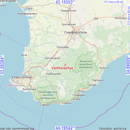
44° 41' 50.568" North, 33° 59' 13.056" East
| Map corner | latitude | longitude |
|---|---|---|
| Upper-left | 45.19503°, | 33.28384° |
| Center: | 44.69738°, | 33.98696° |
| Lower-right: | 44.19542°, | 34.69009° |
| Map W x H: | 111.1×111.1 km | = 69×69mi |
| max Lat: | 52.18903° ⇑97.2% North |
| Verkhorechye: | 44.69738° |
| min Lat: | ⇓2.8% South 44.39214° |
| min Long | Verkhorechye | max Long |
| 22.20555° | 33.98696° | 40.13222° |
| W 62.1%⇐ | ⇒37.9% E |
Elevation
Elevation of Verkhorechye is 238 m = 781 ft, and this is 82.2 m = 270 ft above average elevation for this country.
| Max E: |
886 m = 2907 ft | 22.1% |
| Verkhorechye | 238 m 781 ft | |
| Avg. | 155.8 m = 511 ft | |
Min E: |
-3 m = -10 ft | 77.9% |
See also: Ukraine elevation on elevation.city.
Geographical zone
Verkhorechye is located in North temperate zone (between Tropic of Cancer and the Arctic Circle). Distance of this Northern Tropic circle is 2364 km =1468.9 mi to South.| Distance of | km | miles | from Verkhorechye |
|---|---|---|---|
| North Pole | 5037.2 | 3130 | to North |
| Arctic Circle | 2431.3 | 1510.7 | to North |
| Tropic Cancer | 2364 | 1468.9 | to South |
| Equator | 4969.9 | 3088.2 | to South |


Nearby cities:
15 places around Verkhorechye: (largest is in red/bold)
• Bakhchysarai
12.1 km =7.5 mi,  302°
302°
• Glubokiy Yar
11.9 km =7.4 mi,  331°
331°
• Golubinka
12.8 km =8 mi,  206°
206°
• Kizilovoye
14.2 km =8.8 mi,  18°
18°
• Kuibyshevo
12 km =7.5 mi,  230°
230°
• Nauchny
3.7 km =2.3 mi,  29°
29°
• Novopavlovka
14.1 km =8.8 mi,  351°
351°
• Plotinnoye
12.4 km =7.7 mi,  187°
187°
• Predushchel’noye
9.2 km =5.7 mi,  276°
276°
• Prokhladnoye
6.6 km =4.1 mi,  3°
3°
• Sevastyanovka
14.3 km =8.9 mi,  342°
342°
• Skalistoye
13.3 km =8.3 mi,  356°
356°
• Trudolyubovka
10 km =6.2 mi, 3°
• Turgenevka
12.4 km =7.7 mi,  270°
270°
• Zelyonoye
11.4 km =7.1 mi,  171°
171°
Sources, notices
• [Note1] Compared only with cities in Ukraine existing in our database
• [Src1] Map data: © OpenStreetMap contributors (CC-BY-SA)
• [Src2] Other city data from geonames.org with taken over terms of usage.
• [Src3] Geographical zone / Annual Mean Temperature by Robert A. Rohde @ Wikipedia
