Nadvirna geodata
Nadvirna (Ivano-Frankivsk) is a seat of a second-order administrative division; located in Ukraine in Europe/Kiev (GMT+3) time zone. With population of 20,154 people, there are 198 cities with bigger population in this country. Compared to other cities in Ukraine, 58.5% of cities are located further ↓South; 88.9% of cities are located further →East and 97.1% of cities have lower elevation than Nadvirna. Note1


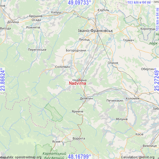
Nadvirna GPS coordinates[2]
48° 38' 5.28" North, 24° 34' 9.696" East
| Map corner | latitude | longitude |
|---|---|---|
| Upper-left | 49.09733°, | 23.86624° |
| Center: | 48.6348°, | 24.56936° |
| Lower-right: | 48.16799°, | 25.27249° |
| Map W x H: | 103.3×103.3 km | = 64.2×64.2mi |
| max Lat: | 52.18903° ⇑41.5% North |
| Nadvirna: | 48.6348° |
| min Lat: | ⇓58.5% South 44.39214° |
| min Long | Nadvirna | max Long |
| 22.20555° | 24.56936° | 40.13222° |
| W 11.1%⇐ | ⇒88.9% E |
Elevation
Elevation of Nadvirna is 428 m = 1404 ft, and this is 272.2 m = 893 ft above average elevation for this country.
| Max E: |
886 m = 2907 ft | 2.9% |
| Nadvirna | 428 m 1404 ft | |
| Avg. | 155.8 m = 511 ft | |
Min E: |
-3 m = -10 ft | 97.1% |
See also: Ukraine elevation on elevation.city.
Geographical zone
Nadvirna is located in North temperate zone (between Tropic of Cancer and the Arctic Circle). Distance of this North polar circle is 1993.5 km =1238.7 mi to North.| Distance of | km | miles | from Nadvirna |
|---|---|---|---|
| North Pole | 4599.4 | 2857.9 | to North |
| Arctic Circle | 1993.5 | 1238.7 | to North |
| Tropic Cancer | 2801.8 | 1741 | to South |
| Equator | 5407.7 | 3360.2 | to South |


Nearby cities:
15 places around Nadvirna: (largest is in red/bold)
• Bili Oslavy
19 km =11.8 mi,  149°
149°
• Bohorodchany
19.3 km =12 mi,  353°
353°
• Bytkiv
7 km =4.3 mi,  265°
265°
• Delyatyn
13 km =8.1 mi,  161°
161°
• Hvizd
5.8 km =3.6 mi, 346°
• Krasna
11.7 km =7.3 mi,  124°
124°
• Lanchyn
16.2 km =10.1 mi, 121°
• Manyava
14.4 km =8.9 mi,  279°
279°
• Markova
12.3 km =7.6 mi,  291°
291°
• Pasichna
12.4 km =7.7 mi,  235°
235°
• Pniv
3.5 km =2.2 mi, 237°
• Sadzhavka
17.8 km =11.1 mi, 115°
• Solotvyn
13.2 km =8.2 mi,  304°
304°
• Tysmenychany
16.8 km =10.4 mi,  25°
25°
• Zarichchya
13.9 km =8.6 mi, 155°
Sources, notices
• [Note1] Compared only with cities in Ukraine existing in our database
• [Src1] Map data: © OpenStreetMap contributors (CC-BY-SA)
• [Src2] Other city data from geonames.org with taken over terms of usage.
• [Src3] Geographical zone / Annual Mean Temperature by Robert A. Rohde @ Wikipedia
