Tysmenychany geodata
Tysmenychany (Ivano-Frankivsk) is a populated place; located in Ukraine in Europe/Kiev (GMT+3) time zone. With population of 2,944 people, there are 961 cities with bigger population in this country. Compared to other cities in Ukraine, 61.6% of cities are located further ↓South; 88.2% of cities are located further →East and 91.3% of cities have lower elevation than Tysmenychany. Note1


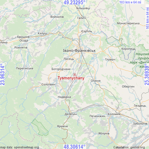
Tysmenychany GPS coordinates[2]
48° 46' 18.048" North, 24° 39' 58.536" East
| Map corner | latitude | longitude |
|---|---|---|
| Upper-left | 49.23295°, | 23.96314° |
| Center: | 48.77168°, | 24.66626° |
| Lower-right: | 48.30614°, | 25.36939° |
| Map W x H: | 103.1×10³ km | = 64.1×64mi |
| max Lat: | 52.18903° ⇑38.4% North |
| Tysmenychany: | 48.77168° |
| min Lat: | ⇓61.6% South 44.39214° |
| min Long | Tysmenychany | max Long |
| 22.20555° | 24.66626° | 40.13222° |
| W 11.8%⇐ | ⇒88.2% E |
Elevation
Elevation of Tysmenychany is 316 m = 1037 ft, and this is 160.2 m = 526 ft above average elevation for this country.
| Max E: |
886 m = 2907 ft | 8.7% |
| Tysmenychany | 316 m 1037 ft | |
| Avg. | 155.8 m = 511 ft | |
Min E: |
-3 m = -10 ft | 91.3% |
See also: Ukraine elevation on elevation.city.
Geographical zone
Tysmenychany is located in North temperate zone (between Tropic of Cancer and the Arctic Circle). Distance of this North polar circle is 1978.3 km =1229.3 mi to North.| Distance of | km | miles | from Tysmenychany |
|---|---|---|---|
| North Pole | 4584.2 | 2848.5 | to North |
| Arctic Circle | 1978.3 | 1229.3 | to North |
| Tropic Cancer | 2817 | 1750.4 | to South |
| Equator | 5422.9 | 3369.6 | to South |


Nearby cities:
15 places around Tysmenychany: (largest is in red/bold)
• Bohorodchany
10.2 km =6.3 mi,  292°
292°
• Bytkiv
21.2 km =13.2 mi,  221°
221°
• Cherniyiv
10.1 km =6.3 mi,  20°
20°
• Chornoliztsi
18 km =11.2 mi,  68°
68°
• Hvizd
12.8 km =8 mi, 221°
• Ivano-Frankivsk
17 km =10.6 mi,  10°
10°
• Nadvirna
16.8 km =10.4 mi,  205°
205°
• Otyniya
14.8 km =9.2 mi,  104°
104°
• Pniv
19.9 km =12.4 mi, 210°
• Radcha
8.8 km =5.5 mi,  354°
354°
• Solotvyn
19.5 km =12.1 mi,  246°
246°
• Stari Bohorodchany
12.5 km =7.8 mi,  303°
303°
• Tysmenytsya
19.5 km =12.1 mi,  42°
42°
• Uhryniv
20.5 km =12.7 mi, 5°
• Zahvizdya
16.3 km =10.1 mi,  356°
356°
Sources, notices
• [Note1] Compared only with cities in Ukraine existing in our database
• [Src1] Map data: © OpenStreetMap contributors (CC-BY-SA)
• [Src2] Other city data from geonames.org with taken over terms of usage.
• [Src3] Geographical zone / Annual Mean Temperature by Robert A. Rohde @ Wikipedia
