Melekyne geodata
Melekyne (Donetsk) is a populated place; located in Ukraine in Europe/Kiev (GMT+3) time zone. With population of 1,356 people, there are 1249 cities with bigger population in this country. Compared to other cities in Ukraine, 64.1% of cities are located further ↑North; 92.1% of cities are located further ←West and 99.8% of cities have higher elevation than Melekyne. Note1


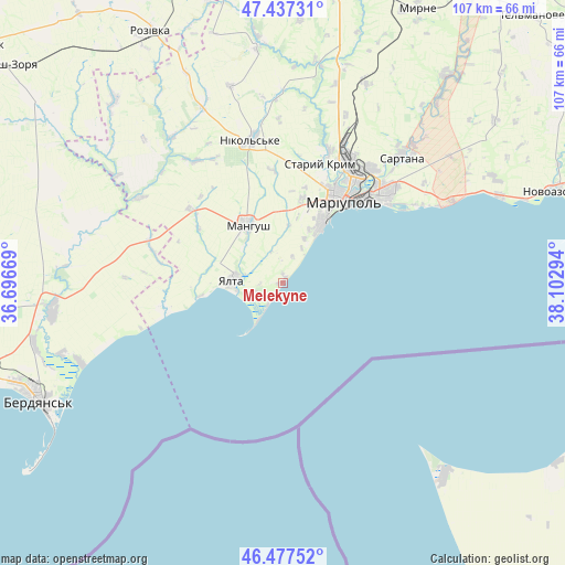
Melekyne GPS coordinates[2]
46° 57' 34.452" North, 37° 23' 59.316" East
| Map corner | latitude | longitude |
|---|---|---|
| Upper-left | 47.43731°, | 36.69669° |
| Center: | 46.95957°, | 37.39981° |
| Lower-right: | 46.47752°, | 38.10294° |
| Map W x H: | 106.7×106.7 km | = 66.3×66.3mi |
| max Lat: | 52.18903° ⇑64.1% North |
| Melekyne: | 46.95957° |
| min Lat: | ⇓35.9% South 44.39214° |
| min Long | Melekyne | max Long |
| 22.20555° | 37.39981° | 40.13222° |
| W 92.1%⇐ | ⇒7.9% E |
Elevation
Elevation of Melekyne is 1 m = 3 ft, and this is 154.8 m = 508 ft below average elevation for this country.
| Max E: |
886 m = 2907 ft | 99.8% |
| Avg. | 155.8 m = 511 ft | |
| Melekyne | 1 m = 3 ft | |
Min E: |
-3 m = -10 ft | 0.2% |
See also: Ukraine elevation on elevation.city.
Geographical zone
Melekyne is located in North temperate zone (between Tropic of Cancer and the Arctic Circle). Distance of this North polar circle is 2179.8 km =1354.5 mi to North.| Distance of | km | miles | from Melekyne |
|---|---|---|---|
| North Pole | 4785.6 | 2973.6 | to North |
| Arctic Circle | 2179.8 | 1354.5 | to North |
| Tropic Cancer | 2615.5 | 1625.2 | to South |
| Equator | 5221.4 | 3244.4 | to South |


Nearby cities:
15 places around Melekyne: (largest is in red/bold)
• Berdyansk
50.5 km =31.4 mi,  244°
244°
• Bezimenne
44 km =27.3 mi,  68°
68°
• Dianivka
51.4 km =31.9 mi,  359°
359°
• Manhush
12.7 km =7.9 mi,  327°
327°
• Mariupol
18.5 km =11.5 mi,  35°
35°
• Nikol's’ke
28 km =17.4 mi,  347°
347°
• Novoazovs'k
54.8 km =34.1 mi, 71°
• Osypenko
43.9 km =27.3 mi,  263°
263°
• Pikuzy
39.3 km =24.4 mi,  52°
52°
• Rozivka
53.5 km =33.2 mi, 332°
• Sartana
32.6 km =20.3 mi, 42°
• Staryy Krym
23.5 km =14.6 mi,  16°
16°
• Temriuk
46.7 km =29 mi,  317°
317°
• Urzuf
23.3 km =14.5 mi, 257°
• Yalta
9.6 km =6 mi,  272°
272°
Sources, notices
• [Note1] Compared only with cities in Ukraine existing in our database
• [Src1] Map data: © OpenStreetMap contributors (CC-BY-SA)
• [Src2] Other city data from geonames.org with taken over terms of usage.
• [Src3] Geographical zone / Annual Mean Temperature by Robert A. Rohde @ Wikipedia
