Osypenko geodata
Osypenko (Zaporizhia) is a populated place; located in Ukraine in Europe/Zaporozhye (GMT+3) time zone. With population of 4,477 people, there are 704 cities with bigger population in this country. Compared to other cities in Ukraine, 64.3% of cities are located further ↑North; 90.5% of cities are located further ←West and 90.9% of cities have higher elevation than Osypenko. Note1


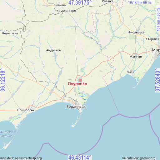
Osypenko GPS coordinates[2]
46° 54' 48.96" North, 36° 49' 31.08" East
| Map corner | latitude | longitude |
|---|---|---|
| Upper-left | 47.39175°, | 36.12218° |
| Center: | 46.9136°, | 36.8253° |
| Lower-right: | 46.43114°, | 37.52843° |
| Map W x H: | 106.8×106.8 km | = 66.4×66.4mi |
| max Lat: | 52.18903° ⇑64.3% North |
| Osypenko: | 46.9136° |
| min Lat: | ⇓35.7% South 44.39214° |
| min Long | Osypenko | max Long |
| 22.20555° | 36.8253° | 40.13222° |
| W 90.5%⇐ | ⇒9.5% E |
Elevation
Elevation of Osypenko is 18 m = 59 ft, and this is 137.8 m = 452 ft below average elevation for this country.
| Max E: |
886 m = 2907 ft | 90.9% |
| Avg. | 155.8 m = 511 ft | |
| Osypenko | 18 m = 59 ft | |
Min E: |
-3 m = -10 ft | 9.1% |
See also: Ukraine elevation on elevation.city.
Geographical zone
Osypenko is located in North temperate zone (between Tropic of Cancer and the Arctic Circle). Distance of this North polar circle is 2184.9 km =1357.6 mi to North.| Distance of | km | miles | from Osypenko |
|---|---|---|---|
| North Pole | 4790.8 | 2976.9 | to North |
| Arctic Circle | 2184.9 | 1357.6 | to North |
| Tropic Cancer | 2610.4 | 1622 | to South |
| Equator | 5216.3 | 3241.3 | to South |


Nearby cities:
15 places around Osypenko: (largest is in red/bold)
• Berdyansk
16.5 km =10.3 mi,  187°
187°
• Chernihivka
59.5 km =37 mi,  302°
302°
• Dianivka
71.2 km =44.2 mi,  37°
37°
• Komysh-Zorya
47.1 km =29.3 mi,  347°
347°
• Kuybysheve
51.2 km =31.8 mi,  344°
344°
• Manhush
40.1 km =24.9 mi,  66°
66°
• Mariupol
57.9 km =36 mi, 69°
• Melekyne
43.9 km =27.3 mi,  83°
83°
• Nikol's’ke
49.6 km =30.8 mi,  49°
49°
• Prymors’k
41.6 km =25.8 mi,  241°
241°
• Rozivka
55.5 km =34.5 mi,  19°
19°
• Staryy Krym
57.4 km =35.7 mi,  61°
61°
• Temriuk
41.2 km =25.6 mi, 16°
• Urzuf
20.8 km =12.9 mi,  89°
89°
• Yalta
34.5 km =21.4 mi, 80°
Sources, notices
• [Note1] Compared only with cities in Ukraine existing in our database
• [Src1] Map data: © OpenStreetMap contributors (CC-BY-SA)
• [Src2] Other city data from geonames.org with taken over terms of usage.
• [Src3] Geographical zone / Annual Mean Temperature by Robert A. Rohde @ Wikipedia
