Rozivka geodata
Rozivka (Zaporizhia) is a seat of a second-order administrative division; located in Ukraine in Europe/Zaporozhye (GMT+3) time zone. In our database, there are 1661 cities with bigger population. Compared to other cities in Ukraine, 61.4% of cities are located further ↑North; 91.1% of cities are located further ←West and 75.7% of cities have lower elevation than Rozivka. Note1


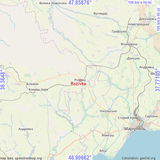
Rozivka GPS coordinates[2]
47° 23' 5.424" North, 37° 4' 4.512" East
| Map corner | latitude | longitude |
|---|---|---|
| Upper-left | 47.85876°, | 36.3648° |
| Center: | 47.38484°, | 37.06792° |
| Lower-right: | 46.90662°, | 37.77105° |
| Map W x H: | 105.9×105.9 km | = 65.8×65.8mi |
| max Lat: | 52.18903° ⇑61.4% North |
| Rozivka: | 47.38484° |
| min Lat: | ⇓38.6% South 44.39214° |
| min Long | Rozivka | max Long |
| 22.20555° | 37.06792° | 40.13222° |
| W 91.1%⇐ | ⇒8.9% E |
Elevation
Elevation of Rozivka is 228 m = 748 ft, and this is 72.2 m = 237 ft above average elevation for this country.
| Max E: |
886 m = 2907 ft | 24.3% |
| Rozivka | 228 m 748 ft | |
| Avg. | 155.8 m = 511 ft | |
Min E: |
-3 m = -10 ft | 75.7% |
See also: Ukraine elevation on elevation.city.
Geographical zone
Rozivka is located in North temperate zone (between Tropic of Cancer and the Arctic Circle). Distance of this North polar circle is 2132.5 km =1325.1 mi to North.| Distance of | km | miles | from Rozivka |
|---|---|---|---|
| North Pole | 4738.4 | 2944.3 | to North |
| Arctic Circle | 2132.5 | 1325.1 | to North |
| Tropic Cancer | 2662.8 | 1654.6 | to South |
| Equator | 5268.7 | 3273.8 | to South |


Nearby cities:
15 places around Rozivka: (largest is in red/bold)
• Blahodatne
43.9 km =27.3 mi,  36°
36°
• Dianivka
25.2 km =15.7 mi,  80°
80°
• Kalynove
30.9 km =19.2 mi,  74°
74°
• Komysh-Zorya
29 km =18 mi,  257°
257°
• Kuybysheve
31.7 km =19.7 mi, 264°
• Manhush
40.9 km =25.4 mi,  153°
153°
• Mariupol
48.1 km =29.9 mi,  132°
132°
• Melekyne
53.5 km =33.2 mi, 152°
• Nikol's’ke
27.6 km =17.1 mi,  136°
136°
• Sartana
52.6 km =32.7 mi,  116°
116°
• Staryy Krym
40.3 km =25 mi, 127°
• Temriuk
14.5 km =9 mi,  206°
206°
• Urzuf
52.2 km =32.4 mi,  177°
177°
• Volnovakha
40.2 km =25 mi,  53°
53°
• Yalta
49.4 km =30.7 mi,  161°
161°
Sources, notices
• [Note1] Compared only with cities in Ukraine existing in our database
• [Src1] Map data: © OpenStreetMap contributors (CC-BY-SA)
• [Src2] Other city data from geonames.org with taken over terms of usage.
• [Src3] Geographical zone / Annual Mean Temperature by Robert A. Rohde @ Wikipedia
